"},{"@type":"PropertyValue","name":"WEB_SEO_TITEL","value":"Rundweg zum Bismarckturm (Kassel, Naturpark-Rundweg 4)"},{"@type":"PropertyValue","name":"WEB_SEO_BESCHREIBUNG","value":"Parallel zum Dönchebach verläuft der stets leicht ansteigende Weg hinauf zum Bismarckturm."},{"@type":"PropertyValue","name":"WEB_SEO_KEYWORDS","value":"Kassel, Rundweg, Naturpark Habichtswald, Wandern, Naturerlebnis, Familientour, Familie, Bismarckturm, Zeche Marie, Dönchebach"},{"@type":"PropertyValue","name":"teaser","value":"Rundtour zum Wahrzeichen des Kasseler Brasselsberges, dem Bismarckturm. Die Wanderung wird mit einer herrlichen Weitsicht belohnt."},{"@type":"PropertyValue","name":"DuplicateGroupId","value":900271900},{"@type":"PropertyValue","name":"experience","value":19000},{"@type":"PropertyValue","name":"experience","value":19278},{"@type":"PropertyValue","name":"ROUTE_HOEHENMETER","value":100},{"@type":"PropertyValue","name":"ROUTE_HOEHENMETER_DESC","value":100},{"@type":"PropertyValue","name":"GROUND_UNKNOWN","value":100},{"@type":"PropertyValue","name":"GROUND_ASPHALT","value":0},{"@type":"PropertyValue","name":"GROUND_GRAVEL","value":0},{"@type":"PropertyValue","name":"GROUND_TRAIL","value":0},{"@type":"PropertyValue","name":"license","value":"CC-BY"},{"@type":"PropertyValue","name":"licenseurl","value":"https://creativecommons.org/licenses/by/4.0/deed.de"},{"@type":"PropertyValue","name":"PeopleCounterShowNumber","value":"false"},{"@type":"PropertyValue","name":"highlight","value":false},{"@type":"PropertyValue","name":"area","value":"Hessen"},{"@type":"PropertyValue","name":"eT4","value":60},{"@type":"PropertyValue","name":"Panorama","value":60},{"@type":"PropertyValue","name":"Kondition","value":60}],"address":{"@type":"PostalAddress","addressLocality":"Kassel","postalCode":"34132","streetAddress":"","addressRegion":"Kassel, documenta-Stadt","addressCountry":"Deutschland"},"amenityFeature":[{"@type":"LocationFeatureSpecification","name":"Rundweg","value":true},{"@type":"LocationFeatureSpecification","name":"Rundtour","value":true},{"@type":"LocationFeatureSpecification","name":"duration","value":60,"unitCode":"MIN"},{"@type":"LocationFeatureSpecification","name":"totalAscent","value":100,"unitCode":"MTR"},{"@type":"LocationFeatureSpecification","name":"totalDescent","value":100,"unitCode":"MTR"},{"@type":"LocationFeatureSpecification","name":"elevationMax","value":447,"unitCode":"MTR"},{"@type":"LocationFeatureSpecification","name":"elevationMin","value":342,"unitCode":"MTR"},{"@type":"LocationFeatureSpecification","name":"difficulty","value":"easy"},{"@type":"LocationFeatureSpecification","name":"round_tour","value":true}],"geo":{"@type":["GeoCoordinates","GeoShape"],"latitude":51.294196,"longitude":9.409211,"line":"51.294196 9.409211 51.294196 9.409211 51.294196 9.409211 51.294196 9.409211 51.294196 9.409211 51.29419 9.40921 51.29418 9.40815 51.2942 9.40708 51.2942 9.40708 51.2942 9.40708 51.2942 9.40708 51.2942 9.40708 51.29416 9.40588 51.29416 9.40587 51.29416 9.40587 51.29416 9.40587 51.29416 9.40587 51.29416 9.40587 51.29424 9.40543 51.29449 9.40447 51.29449 9.40447 51.29449 9.40447 51.29449 9.40447 51.29449 9.40447 51.29486 9.40296 51.29486 9.40296 51.29486 9.40296 51.29486 9.40296 51.29486 9.40296 51.29507 9.40207 51.295322 9.401306 51.295322 9.401306 51.295411 9.400659 51.295411 9.400659 51.29555 9.40015 51.29555 9.40015 51.295646 9.399539 51.295646 9.399539 51.295701 9.399071 51.295701 9.399071 51.29566 9.3987 51.29566 9.3987 51.29554 9.39831 51.29554 9.39831 51.29554 9.39831 51.29554 9.39831 51.29554 9.39831 51.29553 9.39833 51.29535 9.39893 51.29493 9.39981 51.29493 9.39981 51.29493 9.39981 51.29493 9.39981 51.29493 9.39981 51.29473 9.40005 51.2944 9.40018 51.29422 9.40037 51.29422 9.40037 51.29422 9.40037 51.29422 9.40037 51.29422 9.40037 51.29403 9.40068 51.29382 9.40121 51.29382 9.40121 51.29382 9.40121 51.29382 9.40121 51.29382 9.40121 51.29357 9.40158 51.29333 9.40182 51.29333 9.40182 51.29333 9.40182 51.29333 9.40182 51.29333 9.40182 51.29243 9.40254 51.29243 9.40254 51.29243 9.40254 51.29243 9.40254 51.29243 9.40254 51.29176 9.40274 51.29128 9.40293 51.29128 9.40293 51.29128 9.40293 51.29128 9.40293 51.29128 9.40293 51.29122 9.403 51.29115 9.403 51.2911 9.40293 51.29086 9.40335 51.29072 9.40378 51.29072 9.40378 51.29072 9.40378 51.29072 9.40378 51.29072 9.40378 51.29069 9.40386 51.29062 9.4044 51.29053 9.40629 51.29053 9.40629 51.29053 9.40629 51.29053 9.40629 51.29053 9.40629 51.29028 9.40623 51.28979 9.4064 51.28979 9.4064 51.28979 9.4064 51.28979 9.4064 51.28979 9.4064 51.28963 9.40632 51.28953 9.40612 51.28945 9.40555 51.28945 9.40555 51.28945 9.40555 51.28945 9.40555 51.28945 9.40555 51.28958 9.40484 51.28924 9.40448 51.28924 9.40448 51.28924 9.40448 51.28924 9.40448 51.28924 9.40448 51.28912 9.40444 51.28911 9.40444 51.28872 9.4043 51.28801 9.40615 51.28801 9.40615 51.28801 9.40615 51.28801 9.40615 51.28801 9.40615 51.28792 9.40678 51.28802 9.40719 51.28802 9.40719 51.28802 9.40719 51.28802 9.40719 51.28802 9.40719 51.28823 9.40738 51.28852 9.40783 51.28902 9.40844 51.28902 9.40844 51.28902 9.40844 51.28902 9.40844 51.28902 9.40844 51.28915 9.40874 51.2898 9.40934 51.2898 9.40934 51.2898 9.40934 51.2898 9.40934 51.2898 9.40934 51.28995 9.4094 51.28994 9.4094 51.29103 9.40983 51.29103 9.40983 51.29103 9.40983 51.29103 9.40983 51.29103 9.40983 51.2921 9.40966 51.2921 9.40966 51.2921 9.40966 51.2921 9.40966 51.2921 9.40966 51.2929 9.40987 51.29297 9.40973 51.29297 9.40973 51.29297 9.40973 51.29297 9.40973 51.29297 9.40973 51.29312 9.40963 51.29337 9.40951 51.29362 9.409303 51.29362 9.409303 51.293892 9.409143 51.293892 9.409143 51.294108 9.409106 51.294108 9.409106 51.294191 9.409055 51.294191 9.409055 51.294211 9.409129 51.294211 9.409129"},"author":{"@type":["Organization"],"name":" Naturpark Habichtswald","url":"","address":{"@type":"PostalAddress"}},"dateCreated":"2022-03-11T15:18:00+01:00","dateModified":"2025-03-31T14:36:00+02:00","keywords":"Naturerlebnis,Rundweg,Wandern,bismarckturm,dönchebach,kassel,naturpark habichtswald,zeche marie,import_source_toubiz,import_sourceid_38791955-afe1-4a86-9a52-5e2e5c810bec","license":"https://creativecommons.org/licenses/by/4.0/","provider":{"@type":["Organization"],"identifier":["100275678"],"name":"destination.one","url":"http://destination.one/"},"sourceOrganization":{"@type":["Organization"],"name":" Regionalmanagement Nordhessen GmbH","url":"https://www.grimmheimat.de/","address":{"@type":"PostalAddress","addressLocality":"Kassel","postalCode":"34117","streetAddress":"Ständeplatz 17"},"telephone":"+49 (0) 561-97062-240","email":"urlaub@grimmheimat.de"},"url":"https://web.destination.one/tour/rundweg-zum-bismarckturm-kassel-naturpark-rundweg-4"}
Der Naturparkrundweg 4 zum Bismarckturm verläuft parallel zum Dönchebach und steigt stetig leicht an. Etwa auf halber Strecke bietet sich ein Blick auf ehemalige Wirtschaftsgebäude der „Zeche Marie“, die 100 Jahre lang bis 1966 Braunkohle zutage gefördert hat.
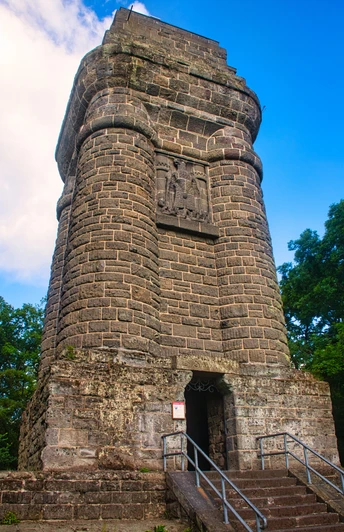
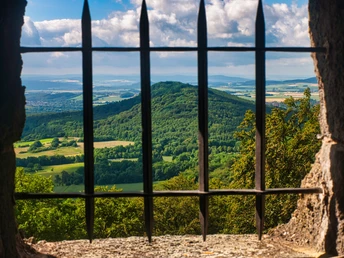
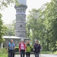
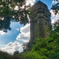
Der 25,5 m hohe Bismarckturm bietet einen fantastischen Blick auf Kassel und das Kasseler Becken. Bei guter Sicht sind der Brocken und der Hohe Meißner zu sehen. Der Turm ist frei zugänglich. Dort befindet sich eine Stempelstation des Mittelgebirgsstürmers.
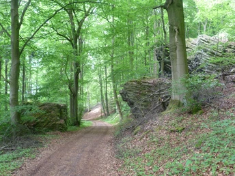
Durch den Wald am Brasselsberg führt der Weg zurück zum Ausgangspunkt.
Gut zu wissen
Beste Jahreszeit
Toureigenschaften
Rundweg
Autor:in
Organisation
Social Media
In der Nähe