Circular route ‘Stier’ (Bull) - Hike around Schönbrunn am Lusen

- 1:30 h
- 4.70 km
- 85 m
- 85 m
- Start: Schönbrunn am Lusen, Village Center/Church, 94545 Hohenau
- Destination: Schönbrunn am Lusen, Village Center/Church, 94545 Hohenau
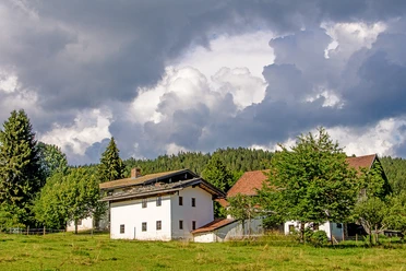
On the circular route ‘Stier’ (Bull), we explore the cultural landscape consisting of forests, meadows, and scattered settlements between ‘Schönbrunn am Lusen’ and ‘Schönbrunnerhäuser’. Along the way, there is information about nature and agriculture on information boards of the "Agricultural Educational Path Schönbrunn am Lusen".
Good to know
Best to visit
- suitableDepends on weather
Tour information
Labelling
Loop Road
Loop Road
Contact person
Hans-Eisenmann-Haus
Nationalparkzentrum LusenBöhmstr. 3594545 HohenauAuthor
Nationalparkverwaltung Bayerischer Wald
Freyunger Str. 294481 GrafenauOrganization
Nationalparkverwaltung Bayerischer Wald
License (master data)

Social Media
Nearby


Download GPX file