- Photos & Map
How would you like to arrive?
- Description
- Good to know
- Nearby
Download GPX file
- 4:05 h
- 15.53 km
- 245 m
- 245 m
- 367 m
- 495 m
- 128 m
- Start: Hikers' parking lot "Zur Glashütte", Bad Wünnenberg-Bleiwäsche
- Destination: Hikers' parking lot "Zur Glashütte", Bad Wünnenberg-Bleiwäsche
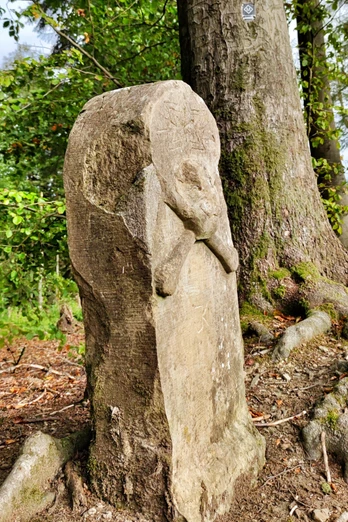
The 15.5-kilometre circular hiking trail takes you to the historic boundary stones between Bad Wünnenberg, in the very south of the district of Paderborn, and the Hochsauerland district.
In addition to the beautiful views offered by the hilly landscape here, highlights include the headwaters of the Kleine Aa, the Schützenwiese and the mystical Totenkopfstein, erected to chase away boundary stone offenders.
Good to know
Pavements
Best to visit
Directions
Route markings
Tour information
Loop Road
Suitable for Winter
Tour with Dog
Equipment
Directions & Parking facilities
In Bleiwäsche, turn left into the road "Zur Glashütte" and follow it to the edge of the forest.
A33 Bielefeld/Brilon, exit at the Bad Wünnenberg-Haaren junction, then continue on the B480 towards Bad Wünnenberg. Take the Bleiwäsche exit and follow the signs to Bleiwäsche.
Further parking facilities at the church in the center of Bleiwäsche.
Stop "Bleiwäsche Kirche"
For more information on traveling by bus, please visit www.fahr-mit.de or call 05251/2930400
Contact person
Author
lokaler Redakteur
Organization
Bad Wünnenberg Touristik GmbH
License (master data)
Bad Wünnenberg Touristik GmbH
Author´s Tip / Recommendation of the author
Safety guidelines
Nearby


