


- 0:25 h
- 5.67 km
- 39 m
- 39 m
- 85 m
- 114 m
- 29 m
- Start: Barmeierplatz (Maiwiese city park), Enger
- Destination: Barmeierplatz (Maiwiese city park), Enger
The KulTour Enger is a historical and cultural city tour of just 5.5 kilometers in length, which takes you to the most important historical and cultural sites in the heart of the Widukindstadt. The main focus here is on the small town's museums and historically interesting buildings.
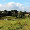
The starting and finishing point of the KulTour is Barmeierplatz in the center of Enger. The Widukind Museum and the collegiate church from the 14th century with Widukind's tomb slab and a precious carved altar are located in the immediate vicinity. Via Nordhofstraße, the route then leads out of the town center to Nordhof, one of five remaining Sattelmeier farms in Enger. There are various explanations for the origin of the term "Sattelmeier". Possibly it stems from the fact that the owners of the farms had to provide a saddled horse in the event of war. The Sattelmeier farms are probably the oldest farms in the region and are now among the largest farms in the Ravensberg region. From here, the route runs along the edge of the village for a while before turning off again towards the town center. Here you reach the small railroad and tannery museums in quick succession, which invite you on a journey back to the heyday of small railways in Bielefeld and the district of Herford and the history of leather production in Enger. The route then describes a southern loop through Enger. After a short detour along the Windmühlenweg, you can reach the Liesberg windmill, Enger's landmark.At the southernmost point of the circular route is the Elsternbusch monument from 1913, which commemorates the end of the French occupation in 1813. From here, the route leads along Kesselstraße and Mühlenstraße in a fairly straight line back towards the city center. Shortly before the starting point at Barmeierplatz is reached again, the Maiwiese on the Bolldammbach invites you to take a break. despite the route leading through the center of Enger, almost exclusively asphalted side roads with very little traffic are used. The tour is very flat, making it suitable for families with children.Further information on the route and the waypoints can be found on the homepage of the town of Enger or the cycle leisure homepage of the district of Herford: www.fahr-im-kreis.de. There you can also download maps and an information brochure free of charge.Waypoints
Good to know
Pavements
Best to visit
Directions
From the starting point of the route at the Maiwiese city park, the route heads north to the Widukind Museum. The route then goes past the collegiate church to the Widukindbrunnen fountain and continues along Brandstraße, which then becomes Nordhofstraße. The route follows this road until behind the Sattelmeierhof Nordhof. There the route turns left into Sattelmeierstraße. A little way past the Enger municipal grammar school, the route turns left and continues east along Windfeldstraße. After approx. 500 meters, the route reaches Ringstraße, which it follows to the right until it reaches Bolldammbach. The route follows this to the left in an easterly direction, past the small railway museum and after crossing the river at Burgstraße, it turns right again into Hasenpatt to the tannery museum. At the end of the street, turn left and then diagonally right across the crossroads into Seelbornstraße. After approx. 600 meters you will find Windmühlenweg on the right-hand side. After approx. 250 meters you will reach the Liesbergmühle, Engers' landmark. After the short detour to the Liesbergmühle, the route returns to Seelbornstraße and at the end of this road, the route turns left to the Elsternbuschdenkmal and then left again up the whole of Kesselstraße. Turn left again at the Protestant hospital and then diagonally right into Mühlenstraße, where you can then turn left into the Maiwiese city park and thus reach the starting point of the route.
Tour information
Familiy-Friendly
Loop Road
Stop at an Inn
Directions & Parking facilities
Additional information
Author
Thomas Wehrenberg
Organization
Touristikgemeinschaft Wittekindsland Herford e.V.
License (master data)

Author´s Tip / Recommendation of the author
Sights along the route:
- Widukind Museum
- Collegiate church
- Widukindbrunnen fountain on Barmeierplatz
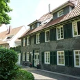
- Nordhof
- Small railway museum
- Tannery Museum
- Liesbergmühle
- Elsternbusch monument
Refreshment stops:
- "Brünger in der Wörde" with beer garden, Enger
- Greek restaurant "Ambrosia", Enger
Further information on the route and the waypoints can be found on the cycle leisure website of the district of Herford: http://www.fahr-im-kreis-herford.de/alle-touren/themenrouten/bauernbad-radelroute
Safety guidelines
1. cycling on the cycle routes is at your own risk, everyone is responsible for themselves.
2.
2. the road traffic regulations apply to all cyclists
.3. a roadworthy bicycle must be used for the cycle tours.
4. The wearing of a bicycle helmet is recommended.
Nearby