- Photos & Map
How would you like to arrive?
- Description
- Good to know
- Nearby
Download GPX file
- 4:00 h
- 16.00 km
- 190 m
- 210 m
- Start: Wanderparkplatz "Dörenther Klippen", Münsterstraße
- Destination: Wanderparkplatz "Dörenther Klippen", Münsterstraße
This 16-kilometre hiking tip combines the hilly, wooded Hermannsweg with a sunny stretch along the southern slopes of the Teuto with views of the Dortmund-Ems Canal and the Münsterland park landscape. On beautifully wooded paths, the Hermannsweg leads over the ridge of the western foothills of the Teutoburg Forest past the "Schönen Aussicht" (beautiful view) in the direction of Bevergern. The trail continues to the Dortmund-Ems Canal with panoramic views of the Nasse Dreieck, where the Dortmund-Ems and Mittelland Canals meet. Along the edge of the forest, the tour tip leads east and offers the hiker beautiful views of stately farms and the Münsterland region again and again. Shortly before the destination, a bench invites you to take a rest and "look far away" into the Münsterland. Now it is only a few hundred metres, then the hiker reaches Münsterstraße and the starting point.
Good to know
Directions
The starting point for this hike is the "Dörenther Klippen" hikers' car park on Münsterstraße in Ibbenbüren. First you have to cross Münsterstraße, then follow the distinctive "H", the official signposting of the Hermann Trail towards the west. Through a sunken path with a considerable incline, you reach a refuge, before the path goes downhill again over "hill and dale".
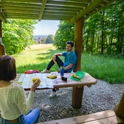
On beautifully wooded paths, the Hermannsweg leads over the ridge of the western foothills of the Teutoburg Forest. Again and again there are beautiful views, the most beautiful of which is certainly from the "Schönen Aussicht". When the weather cooperates, this viewing platform offers a fantastic view of the Münsterland Bay. Tables and benches invite you to rest and have a picnic. Recovered, the hikers set off again and leave the Hermannsweg shortly before the Nassen Dreieck. Fancy a stop for refreshments? Then you should make a detour to the other side of the canal. Cross the bridge, then turn left along the canal and the restaurant at the Nassen Dreieck invites you to coffee, cake, food and cool drinks.
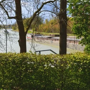
Strengthened, you then walk along the canal again, over the bridge back to the tour tip. You should allow an additional 3 kilometres for this detour. The tour tip now leads the hikers straight ahead across Bergeshöveder Straße onto the cycle path, which leads downhill to the canal. Here you have a wonderful panoramic view of the Nasse Dreieck (wet triangle), where the Mittelland Canal and the Dortmund-Ems Canal meet.
The walkers accompany the Dortmund-Ems Canal on a paved towpath towards the west. At Bergeshövede harbour, you can marvel at large "pots" waiting to be locked along the jetty. Before the hikers leave the towpath along the canal, there is one last opportunity to take a shady rest along the canal. It is also possible to cool off in the canal, but care should be taken here, as the Dortmund-Ems Canal is a traffic route on which many ships are sometimes on the move. After the Bergeshöved bridge, the tour tip leaves the towpath to the left and leads uphill on the "Teutohang" at the edge of the forest.
At the hikers' car park, a detour to the "Schöne Aussicht" (beautiful view) is a good power unit. Even if you were able to enjoy the distant view of Münsterland on the way there, it can be a nice reward after the 256-step climb. An even nicer reward is when your rucksack contains a cool drink. The descent is then much easier. Continue east along the Teutohang along the edge of the forest. Those interested in technology should plan a detour to the Riesenbeck Agricultural Machinery Museum. At the T-junction, the tour tip turns left onto Postdamm, follows it and turns right into Kaisereistraße only a few hundred metres away. This continues along the edge of the forest and offers views of stately farms and the Münsterland region. Turning left, the trail continues along Brumleystraße, which presents panoramic views in many places. A resting bench invites hikers to rest and "look afar".
For those seeking further relaxation in the green, a detour to the NaturaGart park is recommended. With its 77 islands, a maze of waterways with dozens of water lily varieties, the park is reminiscent of a landscape in the Spreewald. In Germany's largest cold-water aquarium, garden ponds and fish can be observed from an unusual perspective through large pond windows. The underwater park with its caves, grottos and a sunken ship is a paradise for divers. Refreshments are available at the Palm Bistro. You should plan an additional three kilometres for this detour to the NaturaGart Park. Now it is only a few hundred metres before the hiker reaches Münsterstraße and the starting point.
This hike has a total length of just under 16 kilometres. The first half follows the Hermannsweg, i.e. only on shady forest paths over hill and dale and with a few inclines. After the hikers have left the forest near the Nassen Dreieck (wet triangle), they reach the sunny side, here sun protection is advisable in appropriate weather conditions.
The second half always leads with a view of the Teutoburg Forest on paved, mainly asphalt paths along the Dortmund-Ems Canal and on the southern slope of the Teutoburg Forest back to the starting point at Münsterstraße. Without detours and detours, there are no refreshment stops on this tour tip. However, there are numerous rest stops along the way, such as at the Schinkensteinhütte or at the Schönen Aussicht, as well as along the canal and at the edge of the forest...
Tour information
Familiy-Friendly
Loop Road
Nature Highlight
Directions & Parking facilities
The starting point of the hiking route is the Dörenther Klippen hiking car park on Münsterstraße in Ibbenbüren.
Getting there by car:
- The car park is located on the B219 federal road (Münsterstraße).
- Not far away, the B219 provides a connection to the A30 motorway.
Arriving by bus and train:
- Ibbenbüren railway station (Rheine - Osnabrück railway line) or Münster (Westf) main station.
- The starting point of the hiking route can be reached by bus line S50 from Ibbenbüren bus station or Münster main station. Bus stop "Dörenther Berg".
Alternative starting point: "Nasses Dreieck" hikers' car park, Bergeshöveder Straße, Hörstel.
- Parking is available at the Dörenther Klippen hikers' car park, Münsterstraße, Ibbenbüren.
- Alternatively, it is also possible to start at the "Nasses Dreieck" hikers' car park, Bergeshöveder Straße, Hörstel.
Contact person
Stadtmarketing Ibbenbüren
License (master data)
Nearby


