


- 2:45 h
- 8.90 km
- 356 m
- 514 m
- 158 m
- Start: Tourist-Information, 54568 Gerolstein, Banhofstraße 4
- Destination: Tourist-Information, 54568 Gerolstein, Bahnhofstraße 4
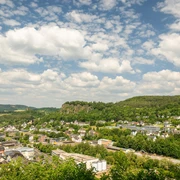
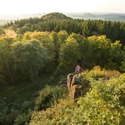
The dolomite rocks are the symbol of Gerolstein and the Gerolsteiner Felsenpfad, or rock trail. The Buchenlochhöhle cave is situated on the edge of the Munterley plateau.
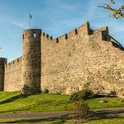
Created over 1.8 million years ago, the cave impresses with its length of around 30 m and breadth of around 4 m. It offered shelter to the stone-age people living here. Through the Vulkanring road, past Germany’s largest mineral thermal spring and the majestic Kasselburg castle, hikers can enjoy great views onto the well town on the return route from the Hustley climbing rocks.
Good to know
Best to visit
suitable
Depends on weather
Author
Eifel Tourismus GmbH
License (master data)
Eifel Tourismus GmbH

Nearby


