


- 1:30 h
- 4.28 km
- 59 m
- 79 m
- 231 m
- 308 m
- 77 m
- Start: Biesnitz, at the foot of the Landeskrone, at the tram line 2 terminus
- Destination: in the Landskronsiedlung, bus stop line A
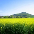
Walk around the Görlitz local mountain Landeskrone and discover the fitness trail and the bee educational trail. The path leads you through the forest and along the fields. You will have a beautiful view of the surrounding area. At the edge of the route is the summit of the Landeskrone (420 meters high) with a wonderful panoramic view and the Bismarck column, a monument created in 1901 by architect Wilhelm Kreis.
The Landeskrone formed about 34 million years ago from a volcano. A linden avenue planted in 1840 begins at the foot of the Landeskrone and meets the basalt cone at the road; 178 steps lead upwards. The hiking trails are well signposted.
Good to know
Pavements
Best to visit
Directions
You start at the terminus of tram line 2. Via the Aufgangstraße you reach the Landeskrone. The Pfaffendorfer Weg leads you southwest along the foot of the mountain past the ski meadow to a crossroads, where you keep right and continue along the foot of the mountain.
After about 250 meters you reach the fitness trail and the bee educational trail. Both run along the old Kirchsteig. There are many stations where you can exercise and many information boards about bees.
At the end of the Kirchsteig you arrive at the Schlauroth district. For those tired, regional bus line 146 returns from here to the Görlitz bus station. Otherwise, continue through the village, where you turn right from Dorfstraße into Schlaurother Straße back towards Landeskrone. There are also signs from the bee educational trail in the village.
We leave Schlaurother Straße to the left into the settlement and follow the Sandweg. This leads to an asphalt footpath towards Carolus Hospital. Now go straight on, where you have another beautiful view of the Landeskrone, and arrive in the Landskronsiedlung, where there is a bus stop at Nelkenweg. With bus line A you return to the city.
Equipment
Day hiking backpack (approx. 20 liters) with rain cover, sturdy and comfortable footwear, weather-appropriate and durable clothing in layers, optionally telescopic poles, sun and rain protection, provisions and drinking water, first aid kit, pocket knife, mobile phone, optionally headlamp, map material
Directions & Parking facilities
- from Dresden via the A4 to the Görlitz junction (94) and continue on the B6 and B99 towards Biesnitz/Landeskrone
- from Cottbus via the B115 and continue on the B6 and B99 towards Biesnitz/Landeskrone
- from Wrocław (Breslau) via the A4 to the Görlitz junction (94) and continue on the B6 and B99 towards Biesnitz/Landeskrone
- from Bautzen/Löbau via the B6 to the Görlitz-Rauschwalde junction and continue via Wiesbadener and Reichenbacher Straße towards Biesnitz/Landeskrone
- from Zittau on the B99 towards Biesnitz/Landeskrone
More information can be found at: www.goerlitz.de/Anreise.html
From the Görlitz train station, take tram line 2 towards Biesnitz to the terminus. Return travel is from the Landskronsiedlung stop via bus line A towards Demianiplatz/University. Further information is available at: https://www.goerlitztakt.de/de/
Additional information
For further information: https://www.visit-goerlitz.com/Natur_Goerlitz.html
Author
Europastadt GörlitzZgorzelec GmbH
Organization
Das Landschaftswunderland Oberlausitz
License (master data)
Europastadt GörlitzZgorzelec GmbH

Safety guidelines
Driving motor vehicles in the nature reserve is strictly forbidden. Exceptions require approval by the Görlitz district nature conservation authority. Please stay on the paths in the nature reserve and observe the notices on the nature conservation signs.
In winter, only limited winter services are provided.
Nearby

