


- 5:59 h
- 22.50 km
- 316 m
- 164 m
- 69 m
- 221 m
- 152 m
The third and final stage of the Solingen Klingenpfad trail begins at Wipperkotten. The trail continues to follow the white in a circle on a black background. From Wipperkotten, head east through Haasenmühle along Ölbergweg. The Klingenpfad winds around the Aufderhöhe district into the Ohligser Heide. The landscape changes here: Away from the woods and floodplains, the path now leads across heath and moorland, some of which can be accessed via footbridges.
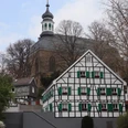
The Ohligser Heide is due to be gradually converted back to a large area of heathland by clearing the tree population that has grown there in recent decades. Flocks of sheep and herds of goats graze here in the summer. Once you have walked across Ohligser Heide, the route takes you through the Ohligs district for a while before reaching the Itter valley. From here, follow the river Itter back to the idyllic town of Gräfrath. This is the end of the third and final stage and the end of the Klingenpfad.
The Ohligser Heide is due to be gradually converted back to a large area of heathland by clearing the tree population that has grown there in recent decades. Flocks of sheep and herds of goats graze here in the summer. Once you have walked across Ohligser Heide, the route takes you through the Ohligs district for a while before reaching the Itter valley. From here, follow the river Itter back to the idyllic town of Gräfrath. This is the end of the third and final stage and the end of the Klingenpfad.
Good to know
Best to visit
suitable
Depends on weather
Tour information
Possibility of Accommodation
Stop at an Inn
Contact person
Stadtmarketing Klingenstadt Solingen
Ms. Sonja Nordmann
Cronenberger Straße 59/61
42699 Solingen
Author
Text: Lilian Möntmann, bearbeitet/übersetzt: Supertext/Home of Translation GmbH
Organization
Bergisches Land Tourismus Marketing e.V.
License (master data)
Text: Lilian Möntmann, bearbeitet/übersetzt: Supertext/Home of Translation GmbH

Our recommendations
Nearby

