


- 5:45 h
- 64.62 km
- 1,243 m
- 1,245 m
- 49 m
- 273 m
- 224 m
- Start: Preußisch-Oldendorf - Bad Holzhausen station
- Destination: Bad Holzhausen Center
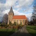
We start at the train station in Bad Holzhausen, a spa town in the Wiehengebirge.
The first stop on our trail outside the town is the castle ruins on the Limberg. The residential tower of this castle is still relatively well preserved with walls that are four meters thick in places. It was probably built in the 12th century. The deep moat and part of the gate through which the outer bailey was accessed are also still intact.
Just below the ridge, we follow a forest path westwards and finally come to the Wiehenturm, a wooden viewing platform from which we can see the forest from above. From here, it becomes clear that we have strayed unnoticed onto a side ridge of the Wiehengebirge, namely the "Egge". On the descent from the Wiehen tower, please take care on the country road: On the opposite side, a narrow path leads down the slope at an acute angle to the road. Inexperienced riders are better off pushing a little.
In the last century, it was not cyclists but miners who could still be seen in the next section of forest. They worked for the Amalia Colliery, where a black rock that was long thought to be coal was mined from 1782 to 1921, with frequent interruptions. From the very beginning, geologists thought this coal was "Spanish" because it was not found as a "seam", i.e. a uniform layer between other types of rock, but rather untidy in fissures and crevices. It was not until 1980 that the geologist Joachim Koch revealed the secret of the coal from Preußisch Oldendorf: "Impsonite" is the name given to a material that is formed from crude oil when exposed to high temperatures. And this is exactly what was painstakingly mined here for so long. There are only a few traces of mining to be found.
We descend to Preußisch Oldendorf via a forest path (watch out for rain here!). Before we leave the path, we pass a quarry on the Linkenberg, which is now quite overgrown and has impressive rock faces that tell us a lot about its geological history.
Passing a former brickworks, we descend to the northern edge of Preußisch Oldendorf. We cross the railroad and the B 65 and arrive in the flat Wiehengebirgsvorland. The next 11 kilometers we cycle comfortably through the plain. We pass through Offelten, Bruchflage, Eikel and Auf der Horst. Finally, we pass the picturesque Gut Stockhausen, a medieval manor that is privately owned and therefore unfortunately cannot be visited. But the outside view is impressive in itself.
The next section shows us just how drastically human activities can change a landscape. One natural area - two faces. The district road takes us through the middle of the Lübbeck industrial area and just a few kilometers later we land directly in the Nettelstedter Moor nature reserve. A landscape has been preserved here that shaped huge areas a few hundred years ago.
On the B 65, we take a closer look at the Königsmühle Eilhausen mill - a must-see, so to speak, as we are in the Minden-Lübbecke mill district. The mill was initially built in 1748 as an "earthen hollow". Around 1900, the upper part was built up with bricks, creating a "gallery mill".
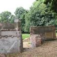
In a sharp left-hand bend, we see a small natural stone structure on the right, slightly off the road, which looks somewhat neglected. It is an old lime kiln that was built in 1945. Six to eight men worked here until the 1950s, producing quicklime for use in construction and as fertilizer.
A little later, we turn right onto a gravel path. It leads along a fence, behind which a large quarry opens up. If you risk a look back here, you can see the sloping layers of rock at the end of the quarry, which were quarried here for the production of road gravel.
We follow winding forest paths along the northern edge of the ridge until we finally cross the ridge after a rather tough climb at Tuddental at an altitude of 230 meters above sea level. Afterwards, we have undoubtedly earned a rest period.
After crossing the village of Hüllhorst, we cycle along the "Gartenweg" above the Nachtigallental. Where we turn right into the valley, a sign points to the Schwefelbad Lusmühle. Until a few years ago, a bell rang down in the valley every day at 2 p.m. on the dot, calling visitors to the baths. The water from a sulphur spring was then brought to a pleasant temperature and everyone was allowed to fight their ailments, big and small, in the strong-smelling water. The spring has been known since 1772 and is considered one of the strongest sulphur springs in North Rhine-Westphalia. However, the future of the baths is uncertain.
We follow the pretty valley back up the stream and shortly before we turn onto the main road, we have the opportunity to fortify ourselves for the next mountain crossing. The "Husenmühle" was extensively renovated a few years ago and now serves as a refreshment stop with a historical background.
Slowly, very slowly, we now approach the Wiehengebirge mountains again, which loom somewhat menacingly in front of us. To the west of the almost 320-metre-high "Heidbrink" mountain, the route leads up to the ridge. At the top, signs point to the "Reineberg". However, this probably refers to the former Reineberg Castle, which once stood on this elevation in the middle of the forest as a massive fortress to withstand all attacks. If you visit the hill today, it is difficult to imagine what it looked like here in the castle's heyday. Instead, there is now a wooden ski jump here, which was probably made by mountain bikers.
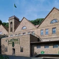
On the north side of the mountain, the route loops slowly along wide forest paths to the town of Lübbecke. It is definitely worth making a detour into the town center here. Lübbecke is a medium-sized town that remained almost unscathed during the war and therefore has beautiful buildings. On the southern edge of the town, we pass a cul-de-sac to the traditional Brewery Barre. - In the "Brewing World" set up there, visitors can learn all about the history of brewing and the House of Barre. - It's better to save the beer tasting on this tour and come back another time. The path now leads steeply up the western flank of the 318-metre-high Wurzelbrink to the ridge. A short descent follows, but this time we stay a little further up on the southern slope. The next ascent is correspondingly shorter, leading us to a parking lot for hikers directly on the country road. The route continues through the forest to the next castle complex: the "Babilonie", which is the subject of numerous legends, is not very spectacular at first glance, but is all the more historically significant. If you want to explore the grounds, you have to wander around on foot. From the castle path, which we use by bike, we can only see part of the ramparts.
In the small village of Obermehnen, we turn left and cycle along the flat northern slope through lush orchards. The trees here benefit from the good soil that was formed during the last ice age. We are now approaching the end of the circular tour, Bad Holzhausen.
We take stock: five mountain crossings in 60 kilometers is quite an achievement. And mostly on forest paths. We can be a little proud of that and end the evening in a relaxed and comfortable way. Perhaps with a cool blonde from crystal-clear mountain spring water.
Good to know
Best to visit
Directions
Tour information
Loop Road
Stop at an Inn
Equipment
Directions & Parking facilities
Always know what's running: The smart number for buses and trains in NRW 01803 504030 (timetable information for €0.09/min from a German landline, mobile max. €0.42/min)
Additional information
Author
Organization
Teutoburger Wald Tourismus
License (master data)

Safety guidelines
Map
Nearby
