- 6:15 h
- 22.56 km
- 180 m
- 279 m
- 96 m
- 280 m
- 184 m
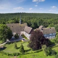
- Start: Naturefriends House Teutoburg Forest, Detmolder Straße 738
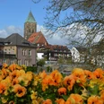
- Destination: Landschaftspflegehof Ramsbrock, Windelsbleicher Straße 242
Since 1995, there has been a flock of sheep in the metropolis of Bielefeld again. It serves nature conservation and maintains species-rich habitats that have become rare in modern times by grazing the meadows. With the sheep grazing project, the Bielefeld Environmental Agency has found a way to maintain the pastures between the Ramsbrock landscape conservation farm, Ubbedissen and the Blömkeberg. The migratory herd has been roaming the countryside with its shepherd Andreas Eisenbart from the Bethel Foundation since 1995.
The main route of the Bielefeld Lamb Trail starts at the Naturfreundehaus Teutoburger Wald and ends at the Ramsbrock landscape conservation farm. The total length of the main route is around 22.6 km. The five sections into which the Lämmerweg is divided are designed as circular hiking trails, meaning that the main trail can also be explored in several stages.The Lämmerweg illustrates the green qualities of the city of Bielefeld particularly well, which are being made even better known to the public via the StadtParkLandschaft project.
Good to know
Best to visit
Directions
From the Naturfreundehaus Teutoburger Wald in Ubbedissen, the trail leads across the Teutoburg Forest, along the Behrensgrund nature reserve and into the Senne. Further on, it touches the Bielefeld airfield and the forest areas of the Bielefeld public utility company. It leads through the "Rieselfelder Windel" bird sanctuary and on through the Windflöte district to the Ramsbrock landscape conservation farm. It follows the migration route of the flock of sheep from the Bethel sheep farm for around 22.6 kilometers.
Note on sectionsThe Lämmerweg can be hiked in five sections. The individual tours have different markings and are also set out as circular tours in the Teuto_Navigator.
The first circular tour starts, like the main route, at the Naturfreundehaus in Ubbedissen. The route leads over the shell limestone ridge into the Lämershagener Tal valley. From there, you reach the Ubbedisser Berg and back to the starting point via the sandstone chain, the Eisgrund parking lot and the Markengrund. The trail stretches over 13.5 km and is the most athletic section of the Lämmerweg with its inclines.
The second circular tour starts from the Eisgrund parking lot and covers a total of 7.9 km. The route leads past the heaths and rough grasslands of the "Behrendsgrund" nature reserve to the B68, continuing through open sandy fields to the edge of the Teutoburg Forest. Following the ridge, you return to the Eisgrund parking lot on forest paths.The third circular tour takes hikers to the "Flugsanddüne" natural monument and Bielefeld airfield. The route then leads through the Windelsbleiche district, forests, meadows and fields back to the starting point. The route is 8.7 km long, but can be extended to 10.7 km by taking a detour.At 18.5 km, the fourth circular tour is the longest of the Lämmerweg. This circular route leads far into the Senneland landscape away from the main trail. It starts at Windelsbleiche railroad station, crosses the "Rieselfelder Windel" bird sanctuary and leads via the Windflöte district to the very scenic Bekelheide. From here, the route returns to Windelsbleiche.The fifth circular tour, at 6.5 km in length, is the shortest in contrast to the fourth circular tour. The outward route leads through the Reiherbach floodplain to the Ramsbrock landscape conservation farm. There, the nature trail invites you to take a short excursion. The way back to the Osthuschule Museum is on paved paths.
Tour information
Stop at an Inn
Directions & Parking facilities
Navigation address:
Naturfreundehaus Ubbedissen
Detmolder Str. 738
33699 Bielefeld
Bollstraße stop on the moBiel line 38 from Stieghorst to Oerlinghausen
.Always know what's running: the smart number for buses and trains in NRW: 01806 504030
(20 cents/connection from landlines and a maximum of 60 cents/connection from mobile networks.)
Additional information
Literature
Brochure "The Bielefeld Lämmerweg - A nature experience guide from the Teutoburg Forest to the Senne"
Protection fee of € 3.00.
Available at the Bielefeld Tourist Information Office, the moBiel Service Center and the Senne District Office.
Author
Dietmar Althaus, Peter Rüther, Hans Schumacher
Organization
Bielefeld Marketing GmbH
License (master data)
Dietmar Althaus, Peter Rüther, Hans Schumacher

Author´s Tip / Recommendation of the author
Sixth discovery tour
Families.Time.Natur Teutoburger Wald/Eggegebirge: With the shepherd on the Lämmerweg into the nature experience
With six "discovery maps", families are invited to experience their homeland in an uncomplicated way and to become active together. Further information can be found here: (link:) Sixth discovery tour
Safety guidelines
The route also crosses major roads in several places. Use the traffic lights and crosswalks.
Please keep dogs on a lead when the flock of sheep is nearby.
Map
Nearby