


- 1:08 h
- 17.13 km
- 63 m
- 61 m
- 89 m
- 160 m
- 71 m
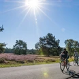
The approx. 17 km long circular tour leads through the Salzkotten districts of Upsrpunge and Verne. Most of the tour is fairly flat, but there are also uphill sections in the southern part of the tour.
Good to know
Best to visit
suitable
Depends on weather
Directions
From the Sälzerhalle in Salzkotten, we head south along Upsprunger Straße ("Hederbornstraße"). At the edge of the village, we turn left into Melkweg and leave the village. When we reach the "Mackeloh" road, we turn right and then cross the L637.
We then follow the "Neue Landwehr" path northwards again, cross the B1 and after a while reach the district of Verne. We follow the signs through the village and then leave it again via the road "Zum Brünneken".
We soon reach the first houses in Salzkotten again and return to the starting point.
We then follow the "Neue Landwehr" path northwards again, cross the B1 and after a while reach the district of Verne. We follow the signs through the village and then leave it again via the road "Zum Brünneken".
We soon reach the first houses in Salzkotten again and return to the starting point.
Tour information
Loop Road
Suitable for Bike
Author
lokaler Redakteur
License (master data)
lokaler Redakteur

Nearby