- 4:40 h
- 18.38 km
- 253 m
- 254 m
- 152 m
- 343 m
- 191 m
- Start: Altstadtmarktplatz (Lange Straße 2, 34414 Warburg)
- Destination: Altstadtmarktplatz (Lange Straße 2, 34414 Warburg)
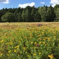
From the tranquil medieval market square of Warburg's old town, the circular route leads along the Diemel. Past the dry slopes of the Diemel valley, the trail leads up into the Warburg Börde. The Desenberg, the region's landmark, can be seen from afar. On a panoramic hiking trail that winds its way around the mountain, you climb around 80 meters in altitude. A fantastic panoramic view over the expanse of the Warburg Börde awaits you, which is well worth the climb. From the summit, you descend again via a trail - into the Diemel valley - and continue back to Warburg's old town.
Good to know
Pavements
Best to visit
Directions
The circular route through the Diemel valley starts at the old town market square in Warburg (Lange Straße 2.). After crossing the Diemel over the Diemel bridge, the trail leads down the Diemel past the old railroad station. After passing the indoor riding arena and the camping site, you can cross the Bundesstraße 7 through an underpass. The route continues through Dalheim and past the Dalheim stud farm to the Diemel bridge. After crossing the Diemel, the path turns right and leads past dry Diemel slopes with calcareous grassland to the Diemelmühle mill. This is where the "ascent" into the Warburger Börde begins. After crossing the railroad line, the trail leads through the wide grain fields of the Warburger Börde, with a view of the Desenberg.
The circular trail leads a short distance to the left along Klingenburger Straße before turning right into Desenbergstraße. At the crossroads, the path turns left towards Desenberg. The ascent to the Desenberg branches off from this road. An ascent to the summit is definitely worthwhile, even if the circular route leads down again at a bench below the summit. The path runs along a field hedge to Klingenburger Straße, which is crossed. It continues through the fields and over the railroad line until it descends into the Diemel valley again. There, the circular route passes the Warburg brewery in the Kuhlemühle and leads back towards Warburg.
Tour information
Familiy-Friendly
Loop Road
Stop at an Inn
Equipment
Directions & Parking facilities
Information for the navigation device:
Lange Straße 2, 34414 Warburg
.(Always know what's running: The smart number for bus and train in NRW 01803 504030)
Additional information
Infocenter Warburg
Tel.: 05641 908800
Internet: www.warburg-touristik.de
Author
Claus Chalas
Organization
Warburg-Touristik e.V.
License (master data)
Claus Chalas

Author´s Tip / Recommendation of the author
Various restaurants in Warburg town center, café at the Eversburg campsite.
At the end of the hike, you should definitely try the Warburg beer in one of Warburg's pubs!
Safety guidelines
The route runs along roads with little traffic (depending on the day of the week). Klingenburger Straße has to be crossed twice. The railroad line is secured with barriers each time.
The descent via the path on the southern slope of the Desenberg requires surefootedness.Nearby