- 54:50 h
- 193.40 km
- 5,294 m
- 5,221 m
- 61 m
- 491 m
- 430 m
- Start: Train station in Siegburg
- Destination: Mudersbach
Hiking from station to station
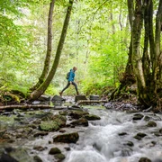
Simply start walking and leave everyday life behind: on rustic paths and trails, the long-distance hiking trail leads through the picturesque Sieg valley and over the surrounding heights. Each of the 14 stages of the Natursteig Sieg starts at a train station and can also be walked individually without much planning. Whether a day trip or multi-day hike: over 14 stages between 11 and 25 km in length, the landscape reveals many attractions: sometimes the route passes impressive natural monuments or rocky passages up to lonely heights. Then along the Sieg or a creek, past castle ruins and half-timbered villages. Choose a stage and travel stress-free by bus or train to the start station of the route. Drivers can also park there, and at the end of the stage, the train conveniently takes you back. The paths are carefully marked and certified as quality trails.
Good to know
Best to visit
Directions
Detailed route descriptions can be found in the individual stages.
Equipment
Sturdy footwear and weather-appropriate clothing
Directions & Parking facilities
Additional information
Literature
Author
Naturregion Sieg
Organization
Rhein-Sieg Tourismus
License (master data)

Author´s Tip / Recommendation of the author
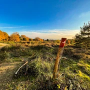
The stages always start and end at a train station!
Map
Stages 1-9: Hiking map "Naturregion Sieg" 1:25,000, ISBN 978-3-86636-911-53, € 6.95
Stages 10-14: Topographic map 1:25,000, Northern Westerwald, sheet 3, ISBN 978-3-89637-252-9, € 6.90
Nearby