- 1:06 h
- 16.95 km
- 251 m
- 268 m
- 160 m
- 318 m
- 158 m
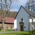
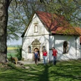
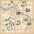
- Start: St. Simon and Judas Thaddäus Church Etteln, Westernstraße 2, 33178 Borchen
- Destination: St. Simon and Judas Thaddäus Church Etteln, Westernstraße 2, 33178 Borchen
Sights worth seeing and knowing:
Catholic parish church in Etteln, Holtsaut Dörenhagen (old above-ground water reservoir).
Good to know
Best to visit
suitable
Depends on weather
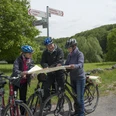
Directions
Starting point Etteln/Kirche - Kirchstraße approx. 300 m in the direction of Henglarn Hissenberg -Busch -Eggeringhausen - approx. 1 km connecting road Dörenhagen/Kirchborchen to the junction Forsthaus Eggeringhausen - through the state forest (Nonnenbusch/Buchholz) back to the starting point church in Etteln.
Route markings
The Borchen cycle routes are signposted continuously from BO1 - BO7. There are white signs with green lettering, most of which are attached as inserts to the cycle destination signposts.
Tour information
Loop Road
Stop at an Inn
Suitable for Bike
Equipment
We recommend wearing a bicycle helmet and clothing suitable for the weather.
Directions & Parking facilities
The municipality of Borchen is well connected to the A33 via the exits "Mönkeloh", "Borchen" and "Borchen - Etteln."
Free parking is available at the church in Etteln.
Author
lokaler Redakteur
License (master data)
lokaler Redakteur

Nearby