- 1:42 h
- 7.06 km
- 13 m
- 13 m
- 99 m
- 112 m
- 13 m
- Start: Am Schloss (near the Holte hunting lodge), 33758 Schloß Holte-Stukenbrock (111 m)
- Destination: Am Schloss (near the Holte hunting lodge), 33758 Schloß Holte-Stukenbrock (111 m)
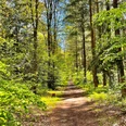
This hiking trail leads mostly through the Holter forest. From the hunting lodge in Schloss Holte, follow the forest path for approx. 3 km following the Schlossweg signs until you turn left onto Brunnenweg. This connects the north and south tangents of the Schlossweg. Follow the Brunnenweg for a few hundred meters and then continue along the Schlossweg in the direction of Schloß Holte. Back on your original route, you will quickly reach the Mühlcafé on the edge of the forest in Verl with its quaint terrace by the mill wheel. The hiking trail then leads another 3 km along the banks of the natural Ölbach stream through sometimes dense, sometimes loosely overgrown forest and through meadows back to Holte hunting lodge, where the Holter Schlosskrug also invites you to linger.

Good to know
Pavements
Best to visit
Directions
Tour information
Familiy-Friendly
Labelling
Loop Road
Nature Highlight
Stop at an Inn
Suitable for Bike
Tour with Dog
Equipment
Directions & Parking facilities
Senne-Bahn Bielefeld - Paderborn: Schloß Holte station (1.7 km).
Bus route 83 Schloß Holte > Bielefeld > Schloß Holte: "Schloßkrug" bus stop.
Always know what's running: The smart number for buses and trains in NRW: 01806 504030 (20 cents/connection from landlines and a maximum of 60 cents/connection from mobile networks.)
Additional information
The hiking trail is included in the free map of the town of Schloß Holte-Stukenbrock and of course at www.stadt-shs.de.
Literature
Author
Stadtverwaltung Schloß Holte-Stukenbrock
License (master data)
Stadtverwaltung Schloß Holte-Stukenbrock

Author´s Tip / Recommendation of the author
Safety guidelines
Map
Nearby