


- 5:00 h
- 17.56 km
- 395 m
- 395 m
- 430 m
- 768 m
- 338 m
- Start: Guest information in Oberkirchen
- Destination: Guest information in Oberkirchen
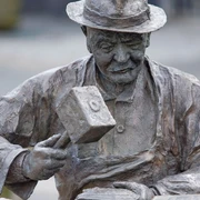
The hike leads along the sculptures "Hexenplatz" and "Krummstab" from the Forest Sculpture Trail from Oberkirchen to the high village Schanze via the Rothaarsteig, past Albrechtsplatz, towards Hoheleye and Westfeld back to Oberkirchen.
Good to know
Best to visit
Directions
The hike begins at the guest information in the center of Oberkirchen. We follow the marking X2 through the Hartmecke valley, then through the Lüttmecke and gradually steadily uphill through the forest past the Hexenplatz to the high settlement Schanze.
Here we stay on the X2 and the broad path, pass the Kyrill Trail and the Krummstab, until we meet the main hiking route X6, the Rothaarsteig and the SR on the ridge of the Rothaar Mountains. We turn left following the signs and hike along the ridge and past the Peace Spring to the road triangle at Albrechtsplatz.
We continue a bit further on the X6, until at the forest edge near Hoheleye (viewpoint) the hiking trail A3/W4 turns sharply left. It leads us downhill and soon to the B236. We stay on the hiking trail A3/W4 until the "Ennest" car park and then keep right without markings from the car park. We leave the sign "Water protection area" on the right.
When we reach a junction, we turn right onto the paved path marked A2 and descend to the wayside shrine above Westfeld. Here we leave the asphalt and go left by the barn without markings until we meet the white crosses of the main hiking trail X2 and follow them left uphill. Soon we reach the height and the wayside shrine "Antonisus Häuschen" and see the Oberkirchen valley ahead with the Wilzenberg behind it. The X2 safely leads us downhill back to the starting point.
Tour information
Cultural Interesting
Loop Road
Stop at an Inn
Directions & Parking facilities
Free parking is available at the hiking car park in the village center.
Bus line S40 operates in Oberkirchen. To get to the starting point, use the "Kirche" stop.
Timetable information: www.rlg-online.de
With the Schmallenberger Sauerland Card, you can travel free of charge by bus and train in the region
Author
Tourist-Information Schmallenberger Sauerland
Organization
Schmallenberger Sauerland Tourismus
License (master data)

Author´s Tip / Recommendation of the author
Map
Nearby

