


- 3:30 h
- 13.00 km
- 238 m
- 238 m
- 156 m
- 258 m
- 102 m
- Start: Paderborn, Haxtergrund (parking lot at Bistro Waldklang)
- Destination: Paderborn, Haxtergrund (parking lot at Bistro Waldklang)
An extended day hike of around 21 kilometers on the Old Pilgrims' Trail is certainly not for everyone. For those who prefer shorter hikes, we would like to invite you to take this 13-kilometre "northern loop" on the Old Pilgrims' Trail.
The hiking route runs from Haxtergund to the Madonna am "Stern" and on to Hamborn Castle. From there, you follow the Kapellenweg to the idyllic Hillige-Seele chapel, which is home to a lovingly designed nativity scene at Christmas time.
A beautiful chestnut avenue now leads back down into the valley. But before you reach the starting point again a good half hour later, you have to climb briefly and steeply uphill to finally arrive back at the starting point in Haxtergrund via beautiful forest paths and with a really good feeling.

Good to know
Pavements
Best to visit
Directions
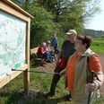
From the parking lot at Bistro Waldklang, we first take the asphalt main path. Here we see an information board about the Old Pilgrims' Trail. We turn left and bypass the barrier at the forest school. We then turn right and pass the wooden bridge over the (mostly dry) Ellerbach with the banner of the Old Pilgrims' Trail. At the edge of the forest, at the insect hotel, we keep left and then continue along the gravel path on the right-hand edge of the Ellerbach valley. We follow the asphalt path to the right and head towards the edge of the forest. There we keep left. After the left-hand bend, the asphalt ends and we continue on the slightly ascending gravel path. At a refuge, we keep straight ahead. We continue slightly downhill on a grassy path. We continue along the asphalt path to the left and after a few meters reach the "Stern" crossroads with a picture of the Virgin Mary.
We take the first path on the right and follow the Ellerbach stream for around 300 meters through the valley. At the left-hand bend, we turn right and climb uphill on a gravel path. After about 500 meters, we keep left. Now we can enjoy beautiful views over the Haxtergrund. At the edge of the forest, we turn right. Shortly afterwards, our path becomes asphalted. We walk past the fruit farm and the perennial nursery at Hamborn Castle and reach the crossroads. We cross this. We then keep left and walk along a fairly wide path through the forest. After 400 meters we turn left onto the so-called "Dornröschenweg". We follow this beautiful natural path for about 800 meters. At two houses, we come to an asphalt path and continue to the right. We take a path to the right of house no. 97, which leads us downhill to the asphalt road. There we turn left. After 200 meters, we keep right and climb up the stairs on the slope. At the top, we continue to the right. We can see the castle on the left. After 200 meters we reach a T-junction where we keep left. We see the Cafè Alte Schule on the left and the health food store on the right.
2nd stage: Hamborn Castle - Chapel "Zur Hilligen Seele": 2.6 km
We follow the road for about 200 meters, then turn right behind the small wooded area. Keep straight on at the next fork in the road. We walk straight across the junction and continue on a gravel path. The schoolyard is on the right, the school garden on the left. Our path is lined with fruit trees. Now we see the nursery on the right and the farm ahead on the left. At the end of the path, we turn right. At the first crossroads we keep straight on, at the second we turn left into the relatively narrow "Kapellenweg". On the right, we can see the water reservoir built in 1957.
The path runs in a straight line through the beech forest. We cross the asphalted Husener Weg and continue straight ahead past a farm on the Kapellenweg, which can be muddy in some places after rainfall.
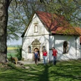
At "Karlsplatz" we come to an asphalted farm track. After a detour to the Hillige Seele chapel, which is well worth seeing, we continue along this path to the left.
3rd stage: Chapel "Zur Hilligen Seele" - Haxtergrund parking lot: 4.9 km
After about 300 meters, we see the "Annabild" from 1956 on the left. A little further on, at the fork in the path, we keep left and walk down into the valley through a beautiful chestnut avenue. At the end, turn right. After 300 meters, an asphalt path joins us from the right. Here we turn left and climb up the slope on a natural path. We eventually come to a forest path, which we follow to the right.
At the crossroads near a refuge, we turn left, but after just 50 meters we turn right. Immediately afterwards, we come to a fork. We take the path on the right, which runs along the edge of the forest. In a dip, we follow the 90-degree left-hand bend. At the end, turn right. We leave this path about 50 meters before a barrier to the left and walk down into the valley and back to the starting point.
Tour information
Familiy-Friendly
Loop Road
Premium Trail "Wanderbares Deutschland"
Stop at an Inn
Equipment
This short tour is also suitable as a winter hike. However, there are a few things to bear in mind to make winter hiking fun.
Clothing: The so-called onion principle is recommended: several thin items of clothing worn on top of each other allow you to react quickly to temperature differences. Functional clothing wicks sweat away and at the same time protects against moisture and wind. You should not dress too warmly at the start of the hike, as your body temperature rises quickly due to the movement.
Gloves, hat and scarf are a must!
Shoes: Even the best hiking boots can become slippery when snow and ice come into play. Trekking poles increase your sure-footedness.
Provision: Warm (non-alcoholic) drinks are an effective way to keep cool, snacks such as energy bars also help to increase body heat.
Electronic devices: The batteries of cameras and GPS devices lose some of their capacity at low temperatures. To be on the safe side, you should therefore take spare batteries with you.
Directions & Parking facilities
The city bus line 46 (PaderSprinter) runs from the main train station via the city center to the "Vereinshaus" stop in Haxtergrund. The bus runs according to the timetable, but you must call 05251 6997197 (Mon.-Fri. 8 a.m. - 5 p.m.) at least one hour before departure to register your journey, groups of more than eight people at least 24 hours before departure (call line).
Further information on how to get there by city bus is available at www.padersprinter.de or by phone on 05251 6997222.
Additional information
Königsplatz 10
33098 Paderborn
Tel. 05251 8812980
tourist-info@paderborn.de
www.facebook.com/paderborn.tourismus
www.instagram.com/paderborn.tourismus
Literature
Pocketbook "The most beautiful half-day hikes in the Paderborn region and Eggegebirge" with 20 interesting circular tours through the local region (220 pages). Available at a price of 12.95 euros from Paderborn Tourist Information, bookshops (ISBN: 978-3-9809507-8-7) and - free of charge - from HEFT-Zeitschriftenverlag (Tel. 05251 62624).
Author
Tourist Information Paderborn
Organization
Tourist Information Paderborn / Verkehrsverein Paderborn e.V.
License (master data)
Tourist Information Paderborn / Verkehrsverein Paderborn e.V.

Author´s Tip / Recommendation of the author
If you like taking photos, you should take your camera with you.
The "Zur Hilligen Seele" chapel is best photographed when there are no leaves on the trees. It is illuminated by the sun in the afternoon.
(Incidentally, there is also a 14-kilometre "southern loop" of the Old Pilgrims' Way.)
Safety guidelines
Social Media
Our recommendations
Nearby
