- 8:01 h
- 30.13 km
- 325 m
- 490 m
- 124 m
- 397 m
- 273 m
- Start: Dringenberg Castle (Burgstr. 33, Bad Driburg)
- Destination: Seat of government Paderborn
The starting point of the Landdrostenweg is the "Freiheit", the old immunity square in front of Dringenberg Castle. We walk downhill in an easterly direction through the Upper Gate and follow the road to Neuenheerse. We look out over the beautiful Oese valley and the village of Kühlsen, hidden in the forest, with the Steinberg towering over the landscape behind it. The hiking trail continues uphill through the Oese valley to the right of the road past the former episcopal Mittelmühle and Obermühle mills, both of which are now disused and have become guest houses. The ground to the right of the upper mill, the Röt, made a good brick for centuries, which was produced in a municipal brickworks on the Scharfenstein from the 15th century (closed in 1901).
After a half-hour hike, we reach the wooded area "An den Schwedenbuchen". These beech trees, the strongest in Westphalia, were felled in 1952 for traffic reasons.According to legend, the Swedes tied their horses to these trees during the Thirty Years' War when they plundered and burned down Dringenberg. The square field adjoining this woodland parcel was a Swedish camp during the aforementioned war, the ramparts of which can still be seen. The beech forest slopes here are covered with liverworts in March and in the fall the eye discovers the marsh heartleaf by the waters of the Oese. The Fiele, formerly known as "fidelen", still had a prince-bishop's oil mill and a sheep wash around 1700. It used to form the border between Heerse Abbey and the mining town of Dringenberg. This is also where the newly elected abbess of Heerse was ceremonially received by noble vassals. The hiking trail follows the former road to Dringenberg for 1 km (traffic-free after re-routing). The mill near the Kluskapelle chapel is called the "Suffelmühle"; it was originally a stamping mill, a gypsum mill, which later became a sawmill and then a grinding mill. The gypsum was obtained from the Bollberge near Neuenheerse. It was used as top dressing, especially for clover fields, which were "plastered", but also for the production of flooring. 5/6 of the gypsum produced was sent to the towns of Driburg, Paderborn, Lichtenau and Dringenberg.The tree traffic circle around the Kluskappelle chapel invites you to take a break. There was probably already a hermitage here in the 10th and 11th centuries. It is mentioned in a document from 1330 "To der Clues", next to which was the noble residence of the Lords of Espringen. The knight's seat is documented in 1184. The family died out in the 14th century. However, the "Springer Hof" still existed in 1724 and the field is still called the "Springer Feld" today. The current Kluskapelle chapel was built in 1704, as a chronostichon above the lintel says, and is dedicated to St. Anthony the Hermit. St. Anthony of Padua is also venerated here. On the altar we see both images, the Paduan with baby Jesus and the hermit with the little pig. The windows and stained glass are more recent. The main source of the Oese lies under shady trees; above the grotto is the statue of the hermit. According to popular belief, the water of the spring strengthens eyesight. A trickle of water comes from the nearby Hellewald forest and flows into the Oesebach stream by the chapel. Its source is the Bollerborn, which only flows out of its source area after a downpour and then dries up for a long time.
According to the legend, the Bollerborn is not a very pleasant place. An abbess with her carriage and horses is said to have drowned in the once large spring hole together with the abbey huntsman after he shot the Meier von Hellhof. Perhaps the purchase of the Hellhof in 1613 from the widow of the Hellhofmeier is the cause of the story. An old footpath leads over the top of the Sengenberg to Neuenheerse, the old procession route to the Klus, which was celebrated every year on June 13th. The seven sorrows were depicted on one side and the seven joys of Mary on the other. From the chapel, the hiking trail leads through the road underpass and turns right behind it. The path leading up from the Kluskapelle chapel to the forest is called Schwalchenweg and is part of the old Landdrostenweg, which the Landdrosten used to travel from their official residence in Dringenberg to PAderborn. A plaque in the vestibule of the chapel commemorates the travelers who had to use this perilous path: "gebett für die reisenden". The hill is called "Unterm Gericht". The hill near the Schnelle farmstead is known as Galgenberg. This name is a reminder of the gallows that once stood here. It was a sovereign court of justice. The procurement and maintenance of such a gallows or "wheel" was the responsibility of the noble bailiffs of Schwaney.
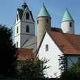
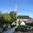
One of the four millers of the Oesebach had to travel to the Oberamt Dringenberg to be sentenced to death. From the place of execution, the delinquent looked longingly at the keep of Dringenberg Castle. If the red flag was raised here, the sentence was carried out; if the white flag was raised, the prisoner was pardoned. The gallows fell down in the middle of the last century. During surveying work, skeletons of those once hanged here were found in the burial mounds. After opening a game gate, we climb up through the deciduous forest on a paved path, then keep left and soon reach the edge of the forest at 386m above sea level. Here the hiking trail leaves the old Landdrostenweg, which is completely overgrown at this point, and runs between a gate and a stand of spruce trees (often very overgrown in summer). You reach a field path almost at the top of the Mittelberg, 400 m above sea level, via a fenced stile. From the top you can see Dringenberg Castle, the mountain mass of the 409m high Steinberg and the southern subsidence field. The Landdrostenweg also goes by the name of Hellweg. On field paths in a westerly direction - past a hunting lodge - we come to the upper Bodental (rich game population). The diverse flora of the limestone zone has receded and been replaced by the sparser flora of the chalky sandy soil. We cross the Eggeweg and follow the ground water westwards, which has been dammed up in a fire-fighting pond. At the edge of the path we find oxidized shards of glass and pieces of clay, evidence of a glassworks that once stood here. After crossing the railroad line (underpass), we enjoy the beautiful view of the Paderborn plateau and its edge. Our path runs parallel to the road to Schwaney, where it ends at the church.
Waypoints
Good to know
Pavements
Best to visit
Directions
Equipment
Author
Bad Driburger Touristik GmbH
Organization
License (master data)
Bad Driburger Touristik GmbH

Author´s Tip / Recommendation of the author
Nearby