


- 3:45 h
- 14.29 km
- 237 m
- 237 m
- 155 m
- 284 m
- 129 m
- Start: Borchen, Hamborn Castle
- Destination: Borchen, Hamborn Castle
An extended day hike of a good 21 kilometers on the Old Pilgrims' Trail is certainly not everyone's cup of tea. For those who prefer shorter hikes, we would like to invite you to take this 14-kilometre "southern loop" on the Old Pilgrims' Trail.
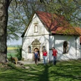
The circular tour runs from Hamborn Castle through the Despental valley up to the "Hunnenwinkel" and then to the "Teufelsstein" viewing rock. From the Kluskapelle St. Lucia chapel on the Altenau and the Kapellenhof farm café, the route leads through the romantic Bilkental valley, then through the "Nonnenbusch" forest area past the cemetery forest to the idyllic Hillige-Seele chapel, which is surrounded by numerous old lime trees. It's worth taking a look inside: in the simple interior, you can literally feel the centuries that this little church has been standing here.
The route continues via the "Kapellenpatt" to the Rudolf Steiner settlement at Hamborn Castle and back to the starting point.
Good to know
Pavements
Best to visit
Directions
The starting point is the overview board in the small parking lot opposite the castle. Descend the steps immediately to the right of the electricity box. The path ends at the road, which we follow to the left. We follow the district road (K 2) for about 20 meters to the left and then turn right onto the field path. The path now runs along the edge of the forest through the Despental valley, slightly but steadily uphill. After just under 1.5 kilometers, at an overview board immediately before entering the forest, we turn right.
The path now climbs steeply along the edge of the forest. At the top, the path bends to the right. An asphalt path branches off to the right, we keep straight ahead and continue along the edge of the forest. At the next fork, we keep left and enter the forest. A few meters further on, we again have two options. We decide to take the right-hand path. We follow this path past a pine grove, then along the edge of the forest until we come to an asphalt path after a good kilometer. There we turn left. At the beginning of the forest, we come to the small "Hunnewinkel" parking lot. We turn left across the parking lot and keep right at the next fork in the path. The forest path leads downhill past a barrier. We reach a T-junction. Here it is advisable to first take a detour to the right to the Teufelsstein (Devil's Stone), around 150 meters away, which offers us a beautiful view over the Altenautal valley.
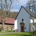
To follow the Old Pilgrims' Trail, we turn left at the T-junction and continue above the Altenautal valley. The path leads around side valleys in two large bends before ending at a T-junction. We turn right and reach the baroque Kluskapelle St. Lucia chapel and the Kapellenhof farm café after just under 400 meters.
(If we don't want to take this detour, we only walk downhill for around 100 meters and then take a sharp left onto the gravel path.)
Stage 2: "St. Lucia" clusters chapel - "Zur Hilligen Seele" chapel: 5.5 km
From the clusters chapel, we walk back along the familiar path for around 300 meters to the fork in the path, where we keep right. We now walk about 1.5 kilometers through the beautiful Bilken valley, gently ascending along the edge of the forest. At the end, we turn left and continue along an asphalt path. At the T-junction, which we reach after around 100 meters, we turn right. We follow the forest path for a good kilometer, then turn left onto a natural path. At the T-junction after about 500 meters, we turn right and walk past the Nonnenbusch cemetery forest. On the right in the forest we see the tastefully designed place of worship. To the left, a path leads to the so-called Lindenplatz, which is ideal for a sunny break.
At the crossroads shortly after the construction trailer, we turn left. In front of us we see the parking lot of the cemetery forest, on our left a picnic bench, a shelter and an overview board of the Old Pilgrims' Trail. We follow the path along the parking lot and walk to the district road (K 2), which we cross in a straight line. We can already see the "Zur Hilligen Seele" chapel ahead on the right. We continue along the grassy path until we reach an asphalt farm track at the so-called "Karlsplatz". We keep to the right and reach the "Zur Hilligen Seele" chapel after just under 100 meters.
Stage 3: "Zur Hilligen Seele" chapel - Hamborn Castle: 2.6 km
We walk back to Karlsplatz. There we take the unpaved path ("Kapellenpatt"), which starts to the right of the bench. The path leads in a straight line along the edge of the forest and can be a little muddy in some places after rainfall.
We pass a farm, cross the asphalt Husener Weg and walk a good 400 meters further along the "Kapellenpatt". At the crossroads where the water tank built in 1957 stands, we turn right. At the next crossroads, we keep straight on. Ahead on the right, we can see the Hamborn Castle estate. At the next opportunity, we turn left. Our path is lined with fruit trees. The schoolyard is on the left and the school garden on the right. We cross the intersection in a straight line. At the end of the path (Binderweg), we turn left.
After the "Alte Schule" café, we turn right. Hamborn Castle is on the right, on the left a little ahead we see a green electricity box and an overview board of the Old Pilgrims' Way.
Tour information
Loop Road
Premium Trail "Wanderbares Deutschland"
Stop at an Inn
Directions & Parking facilities
Additional information
Königsplatz 10
33098 Paderborn
Tel. 05251 8812980
tourist-info@paderborn.de
www.facebook.com/paderborn.tourismus
www.instagram.com/paderborn.tourismus
Literature
Pocket book "The most beautiful half-day hikes in the Paderborner Land and Eggegebirge" with 20 interesting circular tours through the local region (220 pages). Available for 12.95 euros from Paderborn Tourist Information, bookshops (ISBN: 978-3-9809507-8-7) and - free of charge - from HEFT-Zeitschriftenverlag (Tel. 05251 62624, mail@heft.de).
Brochure "The most beautiful Paderborn hikes" with 10 circular tours in and around Paderborn (60 pages). Available for 4.80 euros from Paderborn Tourist Information, Paderborn bookshops and HEFT-Zeitschriftenverlag (tel. 05251 62624, mail@heft.de).
Author
Tourist Information Paderborn
Organization
Tourist Information Paderborn / Verkehrsverein Paderborn e.V.
License (master data)

Author´s Tip / Recommendation of the author
You shouldn't skip the detour to the Teufelstein viewing rock. From there, you can enjoy a great view of the Altenautal valley.
(Incidentally, there is also a 13-kilometre "northern loop" of the Old Pilgrims' Trail.)
Safety guidelines
Social Media
Nearby

