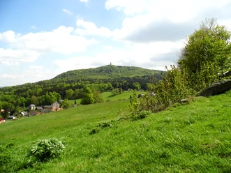
Around Oybin Mountain


- 1:30 h
- 4.92 km
- 174 m
- 175 m
- 391 m
- 477 m
- 86 m
- Start: Guest House
- Destination: Oybin Parking
A pleasant hike around Oybin Mountain with many sights. Discover the spa town of Oybin with all its variety.
Good to know
Best to visit
- suitableDepends on weather
Directions
- Guest House -> Red Line Oybin Station -> Yellow Line along Hausgrund -> Hausgrund Pond -> Left path behind the rock formation of Oybin Mountain to the wooden knight -> Back on the hiking trail -> Past the fairy meadow and the bubbling spring -> Green Dot to the next fork -> Thomas Trail -> Thomas Stones -> Green Dot to the Valley Ring Trail -> Down to the Hölle district -> Road -> Spring Path -> Danzingplatz -> Past the Hubertus House -> Green Dot to the Valley Ring Trail -> Past the ski jump facility -> Road -> Yellow Line to Bürgerallee -> Central Parking Oybin
Tour information
Loop Road
Stop at an Inn
Equipment
- Sturdy footwear
Directions & Parking facilities
- Getting there
From Zittau via Olbersdorf to Oybin
You are also welcome to use a bicycle. Simply check out our current cycling flyer!
ParkingParking lot on Straße der Jugend. Subject to charge.Public transportationBy bus or narrow-gauge railway to Oybin Station from Zittau Station. (ZVON timetables)
Additional information
- www.oybin.com
Author
Tourismuszentrum Naturpark Zittauer Gebirge
Organization
Das Landschaftswunderland Oberlausitz
License (master data)
Tourismuszentrum Naturpark Zittauer Gebirge

Author´s Tip / Recommendation of the author
- Visit the castle and monastery complex on Oybin Mountain. There are places to eat along the hiking trail.
Map
- Saxony Cartography GmbH Dresden - No. 39 Zittau Mountains - Scale 1 : 25,000
Nearby


Download GPX file