


- 7:50 h
- 26.37 km
- 675 m
- 682 m
- 85 m
- 210 m
- 125 m
This stage is a tough one!
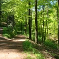
Not only because of its length, but also because of the strenuous ups and downs along the Wupper slopes for the first ten kilometres, this stage can definitely be described as challenging. On the other hand, there are lovely places to stop for a bite to eat along the way, e.g. in Obenrüden and Altenberg, and the first views of Cologne Cathedral!
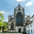
This stage leads to the ‘cradle of the Bergisches Land’: Altenberg was once the site of the first castle of the Counts of Berg, who gave the region its name. Today, the former Cistercian church of Altenberg - the ‘Bergisch Cathedral’ - is particularly impressive. The route there first leads through the Wupper valley. One of the oldest drinking water reservoirs in Germany is located along the way, as are old grinding mills and the enchanted Lambertsmühle mill near Burscheid. A detour to the flower town of Leichlingen, whose surrounding area is known as the ‘fruit chamber of the Bergisches Land’, is also tempting.
Walking time: approx. 9 hours
If you hike the Bergischer Weg and take photos at certain locations, you can collect points and receive a hiking pin. Further information is available here.
Not only because of its length, but also because of the strenuous ups and downs along the Wupper slopes for the first ten kilometres, this stage can definitely be described as challenging. On the other hand, there are lovely places to stop for a bite to eat along the way, e.g. in Obenrüden and Altenberg, and the first views of Cologne Cathedral!
This stage leads to the ‘cradle of the Bergisches Land’: Altenberg was once the site of the first castle of the Counts of Berg, who gave the region its name. Today, the former Cistercian church of Altenberg - the ‘Bergisch Cathedral’ - is particularly impressive. The route there first leads through the Wupper valley. One of the oldest drinking water reservoirs in Germany is located along the way, as are old grinding mills and the enchanted Lambertsmühle mill near Burscheid. A detour to the flower town of Leichlingen, whose surrounding area is known as the ‘fruit chamber of the Bergisches Land’, is also tempting.
Walking time: approx. 9 hours
If you hike the Bergischer Weg and take photos at certain locations, you can collect points and receive a hiking pin. Further information is available here.
Good to know
Best to visit
suitable
Depends on weather
Directions
From Burg, the route initially follows partly stony paths through the wooded slopes along the Wupper, before the path leads from Fähr along forest and farm tracks to the Diepental dam. Cologne Cathedral can be seen for the first time at Bremersheide. The route continues along low-traffic roads and country lanes to Bornheimer Bach and the second view of the cathedral near Kämersheide, before reaching the historic Lambertsmühle mill in Wiembachtal. The Bergischer Weg leads along the Landscheider Bach stream to Sträßchen and finally down into the idyllic Eifgenbachtal valley, which flows into the Dhünntal valley shortly before the stage finish, on the edge of Altenberg. In Altenberg, one of the highlights of the Bergisches Land awaits tired hikers in the form of Altenberg Cathedral.
- Marked access route at the start of the stage: 0.7 km (to Schloss Burg, "Schloss Burg" stop)
- No marked access route at the end of the stage, as it is located directly in Odenthal-Altenberg at Altenberg Cathedral
Tour information
Labelling
Premium Trail "Wanderbares Deutschland"
Directions & Parking facilities
Free car parks in Unterburg (Schlossbergstraße) and at Burg Castle
by bus 653, 683, 687, 689 to the bus stop ‘Solingen-Burg Brücke’; or by bus 266, 687, 689 to ‘Solingen-Burg Schloss’ (then take the access road or cable car)
More information
On the Bergischer Weg (stage 5), several trees have fallen in the Eifgenbach valley on the narrow section between the Schöllerhof junction and Märchenwald, blocking the path. A diversion via the hiking trail running parallel above is now marked with the signpost ‘Bergischer Weg’. Thank you for your understanding. (Status: 24.03.2022)
During the floods in July '22, the bridge at Obenrüdener Kotten was washed away. Therefore, the village of Obenrüden and the Rüdenstein restaurant can only be reached via the Rödeler Brücke bridge in Fähr (via the Untenrüden access route). Alternatively, you can cross the Wupper at the Wupperhof and walk to Obenrüden on the northern side of the Wupper (follow the triangle markings). (Status: 24/02/2022)
A map with the closures can be found in the download area.
Author
Das Bergische GmbH - Bergisches Haus
Friedrich-Ebert-Straße 75
51429 Bergisch Gladbach
Organization
Das Bergische GmbH - Bergisches Haus
License (master data)
Das Bergische GmbH - Bergisches Haus

Social Media
Nearby

