Circular hiking trail through the karst landscape over the Rötzel and Ührde (No. 4)


- 5:55 h
- 22.35 km
- 470 m
- 495 m
- 178 m
- 304 m
- 126 m
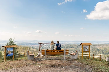
Circular hiking trail through the diverse Osterode karst landscape starting directly on the outskirts of town (Dreilinden elementary school). Initially, you head via the Hördener Breite to the "Devil's Tower", then through the fields with a wonderful distant view up to the karst hiking trail on the Rötzel. Once there, you can enjoy a magnificent view over the hilly landscape, partially with grazing livestock. Directly at the Rötzel, there is a stamping point of the Harzer Wandernadel and a cozy bench invites you to rest. On an information board, you can learn about the special features of the region's flora and fauna. The trail continues towards Beierstein following the karst hiking trail to Ührde. There is a place to eat on weekends. From there, it goes back towards Klingenhagener Weg, passing a riding stable to the starting point.
Good to know
Best to visit
Author
Stadt Osterode am Harz
Organization
Harz: Magische Gebirgswelt
License (master data)

Nearby