


- 4:15 h
- 14.69 km
- 317 m
- 317 m
- 388 m
- 483 m
- 95 m
- Start: Church square Bad Fredeburg
- Destination: Church square Bad Fredeburg
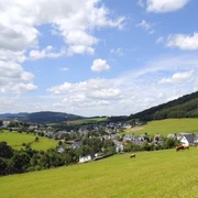
This somewhat longer circular route takes you from the center of Bad Fredeburg via Ebbinghof to Berghausen. In between, you will find wide meadows and sections that lead through forests. At various points, you have wonderful views of the surrounding villages.
Good to know
Best to visit
Directions
Always follow the hiking sign BF3.
Tour information
Loop Road
Stop at an Inn
Equipment
Directions & Parking facilities
Additional free parking is available at the Sauerland Baths parking lot on the outskirts, towards Ebbinghof.
Timetable information: www.rlg-online.de
With the Schmallenberg Sauerland Card you travel free of charge by bus and train in the region
Additional information
All important information about Bad Fredeburg can be found at: www.bad-fredeburg.de
Author
Bad Fredeburg Gewerbe und Touristik
Organization
Schmallenberger Sauerland Tourismus
License (master data)

Author´s Tip / Recommendation of the author
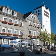
Arrived in Berghausen, a visit to the newly renovated St. Cyriakus parish church is worthwhile.
Safety guidelines
In the Hochsauerland district, an emergency point system is installed. Emergency points can be found, among others, on the information boards at the junctions and hiking signage.
Map
Hiking map Schmallenberg, scale: 1 : 25,000
Hiking map Bad Fredeburg, scale: 1 : 20,000
Nearby
