


- 4:00 h
- 13.12 km
- 405 m
- 407 m
- 422 m
- 623 m
- 201 m
- Start: Church square Bad Fredeburg
- Destination: Church square Bad Fredeburg
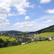
The route leads steadily uphill from the church square in Bad Fredeburg through the Bad Fredeburg forests. Via the Sauerländer Höhenflug, past the old forester's house, you finally reach the small village of Altenilpe. From there it goes towards Sellinghausen. On the way back to the town centre of Bad Fredeburg, you will pass the Sellinghausen golf course.
Good to know
Best to visit
Directions
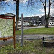
Always follow the hiking sign BF4.
Tour information
Loop Road
Stop at an Inn
Equipment
Directions & Parking facilities
Timetable information: www.rlg-online.de
With the Schmallenberger Sauerland Card you can travel free of charge by bus and train in the region
Additional information
Everything important about Bad Fredeburg can be found at: www.bad-fredeburg.de
Author
Bad Fredeburg Gewerbe und Touristik
Organization
Schmallenberger Sauerland Tourismus
License (master data)

Safety guidelines
A rescue point system is installed in Hochsauerlandkreis. You can find rescue points, among others, on the information boards at junctions and on the hiking signage.
Map
Hiking map Schmallenberg, scale: 1 : 25,000
Hiking map Bad Fredeburg, scale: 1 : 20,000
Nearby