


- 4:29 h
- 14.12 km
- 407 m
- 275 m
- 335 m
- 619 m
- 284 m
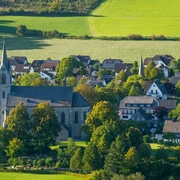
- Start: Parish Church St. Pankratius Reiste
- Destination: Tourist Information Bad Fredeburg
The hiking taxi brings holders of the Schmallenberger Sauerland Card comfortably and free of charge every Saturday and Sunday to various starting points on the Sauerland Höhenflug in Reiste and Bad Fredeburg. From both directions, you can hike the long-distance trail as a day stage (approx. 4 - 5 hours). Simply register your trip by 6:00 p.m. the day before at Taxi Spieler by calling 02972 / 921092. Please also register dogs!
The starting opportunities:
10:00 a.m. at the bus stop "Sparkasse" in Bad Fredeburg
10:45 a.m. at the bus stop "Reiste"
(every Saturday and Sunday)
Guests staying in the following districts are picked up on site by the Höhenflug taxi as part of this route: Altenilpe, Sellinghausen, Kirchilpe, Landenbeck, Kleins Wiese, Rimberg, Oberrarbach, Kirchrarbach, Oberhenneborn. The exact departure times on site will be communicated to you when registering.
Good to know
Best to visit
Directions
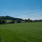
You start your route at the parish church St. Pankratius in the center of Reiste. Follow the signage of the Sauerland Höhenflug (SH) in a southeast direction (Bad Fredeburg). At Gelsterhagen, you have a fantastic view far into the Schmallenberger Land. The Sauerland Höhenflug then continues to Bad Fredeburg.
Equipment
We recommend sturdy footwear and enough provisions for your hike.
Directions & Parking facilities
Use the hiking taxi to the Sauerland Höhenflug and discover a stage of the long-distance hiking trail (for holders of the Schmallenberger Sauerland Card).
More information can be found at: www.schmallenberger-sauerland.de
Alternatively, you can also arrive by public transport.
Parking is available at the Marktweg parking lot or at the Eslohe-Reiste hiking portal.
Guests with a valid Schmallenberger Sauerland Card pay a fare contribution of 2€ for adults and 1€ for children for the hiking taxi.
Further information: www.sauerland-card.de
Public transport schedule information: www.rlg-online.de
Author
Schmallenberger Sauerland Tourismus
Organization
Schmallenberger Sauerland Tourismus
License (master data)

Author´s Tip / Recommendation of the author
Viewpoint "Gelsterhagen"
At several points, Gelsterhagen opens up fantastic views far into the Schmallenberger Land. You can see the church in Wormbach, the Härdler in the Rothaar Mountains, and even the Nordhelle in the Ebbe Mountains. Explanations are provided by the panorama board at the roadside. At several spots, benches invite you to enjoy the view.
Safety guidelines
In the Hochsauerland district, a rescue point system is installed. Rescue points can be found among other places on the information boards at junctions and on hiking signs. All signposts on this route are marked with official location numbers as rescue points.
Map
Hiking map Schmallenberger Sauerland: Scale 1 : 25,000
Nearby