


- 4:30 h
- 14.30 km
- 312 m
- 402 m
- 335 m
- 619 m
- 284 m
- Start: Tourist Information Bad Fredeburg
- Destination: Parish Church St. Pankratius Reiste
Comfortable to the Sauerland Höhenflug
The hiking taxi brings holders of the Schmallenberger Sauerland Card conveniently and free of charge every Saturday and Sunday to various starting points in Reiste and Bad Fredeburg. From both directions, you can hike the Sauerland Höhenflug as part of a day stage (approx. 4-5 hours). Simply register your ride by 6:00 pm the day before at Taxi Spieler by phone number 02972/921092. Dogs must also be registered.
The starting options (Saturday & Sunday):
10:00 am at the bus stop "Sparkasse" in Bad Fredeburg
10:45 am at the bus stop "Reiste" to start in Bad Fredeburg.
Guests staying in the following districts will be picked up on site by the hiking taxi as part of this route: Altenilpe, Sellinghausen, Kirchilpe, Landenbeck, Kleins Wiese, Rimberg, Oberrarbach, Kirchrarbach, Oberhenneborn.
The exact departure times on site will be communicated to you upon registration.
Good to know
Best to visit
Directions
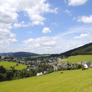
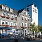
You start your route at the Tourist Information in the center of Bad Fredeburg. From the parish church Bad Fredeburg, you can follow the signage of the Sauerland Höhenflug (SH) in a north-western direction (Reiste). At Gelsterhagen you have a fantastic view far into the Schmallenberger Land. The Sauerland Höhenflug then leads you via Kirchilpe to Reiste.
Tour information
Stop at an Inn
Equipment
We recommend sturdy footwear and sufficient provisions for your hike.
Directions & Parking facilities
Use the "hiking taxi" (Saturday & Sunday, for holders of the Schmallenberger Sauerland Card) and discover the Sauerland Höhenflug.
Further information can be found at: www.sauerland-card.de
Alternatively, you can also arrive by car.
In Bad Fredeburg, hikers can park either at Schützenplatz or at SauerlandBad.
The SauerlandBad is located on the street "Sportzentrum". To get to the town center and thus to the Sauerland Höhenflug, follow "Leißestraße", which meets the street "Mothmecke". First turning left, then right, you will reach the church in the center of Bad Fredeburg after only a few minutes. The Sauerland Höhenflug runs directly across the church square. From here, you can continue either towards Altastenberg or to Reiste.
Lennestadt - Altenhundem station
Bus connection: bus line SB 9 continuing with S 90
Meschede station
Bus connection: bus line S 90 or bus line S 70 and continuing with bus line 369
Winterberg station
Bus connection: bus line S 40 continuing with S 90
For guests with a valid Schmallenberger Sauerland Card, bus travel on public transport is free!
Further information can be found at www.sauerland-card.de
Timetable information for public transport: www.rlg-online.de
Author
Tourist-Information Schmallenberger Sauerland
Organization
Schmallenberger Sauerland Tourismus
License (master data)

Author´s Tip / Recommendation of the author
Viewpoint "Gelsterhagen"
At several points, Gelsterhagen opens up fantastic views far into the Schmallenberger Land. You can see the church in Wormbach, the Härdler in the Rothaar mountains, and even the Nordhelle in the Ebbe mountains. Explanations are provided by the panorama board at the roadside. Benches invite you to enjoy the view at several points.
Safety guidelines
A rescue point system is installed in the Hochsauerland district. You will find rescue points, among other places, on the information boards at junctions and hiking signage.
Map
Hiking map Schmallenberger Sauerland: Scale 1:25,000
Nearby
