


- 1:25 h
- 20.75 km
- 162 m
- 162 m
- 85 m
- 138 m
- 53 m
- Start: Jahnplatz (Ringstraße / Bolldammstraße in Enger)
- Destination: Jahnplatz (Ringstraße / Bolldammstraße in Enger)
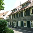
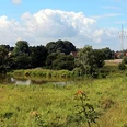
This rural circular route around the Widukind town of Enger offers culture and relaxation in peaceful surroundings and leads through the gently rolling countryside. The Widukindstadt Enger is the start and finish point. Jahnplatz is the best starting point. From here, it is only a short distance to the Enger Bruch nature reserve. With a bit of luck, you may spot rare migratory and breeding birds. Leaving the Bruch behind you, you will reach the Sattelmeierhöfe farms in Westerenger. Ringsthof is also the highest point of the route. In Pödinghausen, there are several places to stop for food and drink before you pass two more historic farms in Oldinghausen. For a particularly nice picnic during the cycle tour, the Liesbergmühle in Enger is a must. Situated on a hill, the fantastically restored windmill offers a wonderful vantage point. From here, you return to the historic town center of Enger. Listed houses, churches worth seeing, old factories and small but very fine museums round off the tour.
The route leads almost exclusively along roads with little traffic, independent cycle paths and paved farm tracks, some of which are closed to through traffic. This means that the circular route is also suitable for families with children.
Further information on the route and the waypoints can be found on the Herford district cycling leisure website: www.fahr-im-kreis.de. A brochure is also available there as a free download.
Waypoints
Good to know
Pavements
Best to visit
Directions
From the start and finish point at Jahnplatz, the route heads west to the Enger Bruch nature reserve. At Westerengerstraße, the route turns south to head east again via Ringsthofstraße past Sattelmeierhof Ringsthof and through Pödinghausen. After the Oldinger Mark, the route heads north again and through Bexten. The route then heads west past the Sattelmeier farms Ebmeyer and Meyer-Johann and back to Enger. The route continues past the collegiate church to the northernmost point of the route at Sattelmeierhof Nordhof and from there back to the starting point at Jahnplatz.
The route follows the roads:
- Jahnplatz (Ringstraße / Bolldammstraße in Enger)
- Bruchweg (cycle path)
- Wertherstraße
- Westerengerstraße
- Ringsthofstraße
- Jöllenbecker Straße
- Sundernstraße
- Markstraße
- Oldinghauser Straße
- Sandstraße
- Markgarten
- Balker Busch
- Schulstraße
- Seelbornstraße
- Elsternbuschweg
- Seelbornstraße
- Wertherstraße
- Hasenpatt
- Burgstraße
- Kirchplatz
- Stiftsweg
- Church square
- Steinstraße
- Renteistraße
- Steinstraße
- Nordhofstraße
- Sattelmeierstraße
- Tiefenbruchstraße
- Ringstraße
- Spenger Street
- Enger Kleinbahnhof
- Bolldammbach cycle path
- Bolldammstraße
- Jahnplatz (Ringstraße / Bolldammstraße in Enger)
Tour information
Familiy-Friendly
Loop Road
Stop at an Inn
Directions & Parking facilities
Additional information
Literature
Brochure Memorial Route Enger
Author
Thomas Wehrenberg
Organization
Touristikgemeinschaft Wittekindsland Herford e.V.
License (master data)

Author´s Tip / Recommendation of the author
Stations:
- Sattelmeierhof Baringhof (Baringhof 1)
- Sattelmeierhof Ringsthof (Ringsthof 1)
- Sattelmeierhof Ebmeyer (Schulstraße 180)
- Sattelmeierhof Meyer-Johan (Seelbornstraße 122)
- Elsterbuschdenkmal (Elsternbuschweg / Seelbornstraße)
- Liesbergmühle (Windmühlenweg 24)
- Gerberei Sasse (Hasenpatt 4)
- Collegiate Church (Kirchplatz 1)
- Widukind Museum Enger (Kirchplatz 10)
- Old Slate House (Kirchplatz 13)
- Former Farmhouse (Steinstraße 17)
- Former customs office + music school (Kirchstraße 2)
- Sattelmeierhof Nordhof (Nordhofstraße 1)
- Old town hall (Ringstraße 65)
- Cigar factory Osterwald (Spenger Straße 13)
- Passenger car HK31 (Bahnhofstraße 54)
Other special features along the way include the Enger Bruch nature reserve, The Bismarck Oak and the historic town center of the Widukindstadt Enger.
The route also has culinary delights to offer:
- Baker, snack bar, restaurant, Pödinghausen
- Zum Weißen Stein, Oldinghausen
- Gastronomic establishments in the town center of Enger
Further information on the route and the waypoints can be found on the cycle leisure homepage of the district of Herford: http://www.fahr-im-kreis-herford.de/alle-touren/denkmal-routen/denkmal-route-enger
Safety guidelines
1. cycling on the cycle routes is at your own risk, everyone is responsible for themselves.
2.
2. the road traffic regulations apply to all cyclists
.3. a roadworthy bicycle must be used for the cycle tours.
4. The wearing of a bicycle helmet is recommended.
Map
Nearby