- 2:47 h
- 9.62 km
- 101 m
- 101 m
- 107 m
- 155 m
- 48 m
- Start: Häger community center, Enger Str. 122, 33824 Werther (Westf.)
- Destination: Restaurant Weinhorst, Enger Str. 123, 33824 Werther (Westf.)
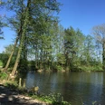
Beautifully scenic hiking route that runs along large sections of the Hägeraner Rundweg. Along the way, you can see the striking and rare Siektäler valleys. The Siektäler valleys are box-shaped depressed wet valleys with a steep embankment edge, which are still largely preserved around Häger. At Spengeraner Nadelholz, one of the highest points on the route offers beautiful views over the Ravensberg hills.
Good to know
Pavements
Unknown
Street
Asphalt
Gravel
Trail
Path
Best to visit
suitable
Depends on weather
Directions
From the community center, turn right along Enger Straße. After a few meters, turn left into Leinenbrink. From there, turn left again into Hägerstraße. Here you can follow the road to Sattelmeierweg or turn right into an alternative path on Hägerstraße. Both paths lead to Sattelmeierweg, which you follow to the left. Here you are on hiking trail 1, but do not follow this trail, but stay on the Sattelmeierweg and then turn right onto the RH, the Häger circular trail. Follow the path past the fish ponds. Stay on the Häger circular route until you reach Werther Straße. Here, turn right into Werther Straße. After a few meters, cross the road and continue along the Nadelholz road. This road is marked A 3. Then follow Zur Landwehr on the right and you will return to Enger Straße.
Tour information
Loop Road
Stop at an Inn
Equipment
Sturdy shoes, drinks for on the way and, if necessary, a second pair of spare shoes for the way back in the car (partly clay soil).
Directions & Parking facilities
Bürgerhaus Häger (only a 2-minute walk from the restaurant)
Always know what's running: The smart number for buses and trains in NRW: 01803 504030
(Timetable information for €0.09/min from a German landline, mobile max. €0.42/min
.Additional information
Author
Marion Lauterbach
Organization
pro Wirtschaft GT GmbH Gütersloh
License (master data)
Marion Lauterbach

Safety guidelines
The tour is not suitable for handcarts and baby carriages. There are few seating options along the way, especially for larger groups.
Nearby