


- 4:00 h
- 12.65 km
- 174 m
- 204 m
- 103 m
- 245 m
- 142 m
- Start: Central bus station Werther (mobility station), Alte Bielefelder Straße 28, 33824 Werther (Westf.)
- Destination: Central bus station Werther (mobility station), Alte Bielefelder Straße 28, 33824 Werther (Westf.)
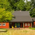
In addition to flat and hilly sections, Werther shows its varied side here. Hikers on the Werther Egge in the direction of Theenhausen are treated to beautiful sweeping views of the surrounding countryside. Not forgetting the natural surroundings of Häger with its fish ponds and striking Siektälern valleys, the Ravensberg light landscapes and - to the south-west of Werther - the Arminius spring.
There is something for everyone here.
Good to know
Pavements
Best to visit
Directions
The entire route of the circular hiking trail is well marked. You start at the Werther central bus station (mobility station). Past the outdoor pool and the residential area, the route heads towards the Teutoburg Forest to the Arminius spring in the direction of Kirchdornberg. Through the district of Isingdorf you reach Schloßstraße. There it is worth making a detour to the Peter August Böckstiegel Museum.
Tour information
Stop at an Inn
Equipment
Sturdy footwear is recommended.
Directions & Parking facilities
Werther (Westphalia) is 10 km away from Bielefeld.
Connection to federal highways:
A 30 / E 8 (Bad Oeynhausen - Osnabrück with continuation in the direction of Münster - Bremen) 18 km to Melle
A 2 / E 73 (Ruhr area - Hanover) 17 km to Bielefeld - Hillegossen or 30 km to Rheda-Wiedenbrück
A 33 (Paderborn - Halle (Westf. )
Parking lot at the central bus station Werther (mobility station), Alte Bielefelder Straße 28, 33824 Werther or
Parking lot on Meyerfeld street (parking lot of the P.A.B. comprehensive school), 33824 Werther (Westf.)
The starting point of the route is the Werther central bus station (mobility station). You can reach the ZOB by public transport.
Always know what's running: The smart number for buses and trains in NRW: 01806 504030 (20 cents/connection from landlines and a maximum of 60 cents from mobile networks.For more information, please visit www.owlverkehr.de
Additional information
Refreshment stops along the way on the 1st stage:
- Hotel u. Restaurant Bergfrieden, Isingdorfer Weg 33, 33824 Werther (Westf.), Tel. 05203 9722-0, www.bergfrieden-werther.de
- Schwedenfrieden, Zur Schwedenschanze 75, 33619 Bielefeld, Tel. 0521 98819881, www.schwedenfrieden.de
- Schwedenschanze with limited weekend operation
Experience the history of our city by booking a guided themed city tour with one of our trained city guides
.For more information, visit www.stadt-werther.de , www.erfolgskreis-gt.de or www.teutoburgerwald.de
Author
Sandra Wursthorn
Organization
Stadt Werther
License (master data)
Sandra Wursthorn

Author´s Tip / Recommendation of the author
Visit the Peter August Böckstiegel Museum at Schloßstraße 111 and take a look at the works of the expressionist painter and sculptor.
Safety guidelines
Not barrier-free
Nearby
