


- 3:00 h
- 8.50 km
- 150 m
- 150 m
- 70 m
- 170 m
- 100 m
- Start: Hiking car park "Siegelsknippen", Siegburg
- Destination: Hiking car park "Siegelsknippen", Siegburg
An easy round on comfortable paths that you can also spontaneously do as a longer walk or after-work round. In the Wahnbach valley, followers of Saint Francis found ideal conditions for a life of silence and seclusion around 800 years ago. Above the valley, a beautiful meadow with hiking loungers and a lake view offers a place to rest.
Good to know
Best to visit
Directions
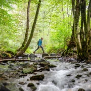
Your circular hike starts at "Siegelsknippen" as a forest walk. A forest path runs through the silence of the Kaldauer Forest. The low-traffic Seligenthaler Street takes you past the ruins of the Ummigstal Bridge, destroyed in the war, to the idyllic monastery complex. Preserved is the monastery church built in the 13th century (the oldest Franciscan church in Germany) and a baroque chapel. The former monastery complex is now used as an event hotel. Through the valley, the path continues partly on narrower forest trails, accompanied from time to time by the lively Wahnbach heading towards the dam. A steep, although short, root path follows to the ridge. Once at the top, you reward yourself with the magnificent view from the dam over the deep blue water surface for your efforts. On a winding uphill road section, you pass fields and orchards to Gut Umschoß. Below the estate, you will find comfortable loungers with a lake view on a meadow. After a passage through a beautiful walnut tree avenue, you will find a natural monument: an old beech tree with an enormous circumference. A path through the Ummigsbachtal, crossing the little stream several times and passing ponds, leads through the forest back to the starting point.
Tour information
Familiy-Friendly
Loop Road
Equipment
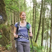
Sturdy footwear and weather-appropriate clothing
Directions & Parking facilities
A3, AS Lohmar, B484 – B56 – Heide entrance.
Hiking car park Siegelsknippen
Lines 511, 577, and SB56 (VRS), to and from Siegburg station; Franzhäuschen stop
Additional information
Stamp point: information panel at the Ummigstal Bridge ruins
The Erlebniswege Sieg are fully marked with the red logo. Boards with overview maps and further information about dining and accommodation options as well as sights can be found at the starting points of each Erlebnisweg.
Literature
Author
Naturregion Sieg
Organization
Rhein-Sieg Tourismus
License (master data)

Author´s Tip / Recommendation of the author
steep short path section to the dam
Monastery church with Romanesque wall tabernacle
Map
Nearby