Erlebnisweg Sieg | Talsperrenweg | Siegburg

22.96 km long
Round trip
Difficulty: difficult
Condition: difficult
Great panorama
Hiking
  • 7:00 h
  • 22.96 km
  • 540 m
  • 534 m
  • 110 m
  • 189 m
  • 79 m
  • Start: Parking lot at the Wahnbach dam, Siegburg-Seligenthal. Alternative: Hikers' parking lot in Wolperath, Neunkirchen-Seelscheid
  • Destination: Parking lot at the Wahnbach dam, Siegburg-Seligenthal. Alternative: Hikers' parking lot in Wolperath, Neunkirchen-Seelscheid
Erlebnisweg Sieg - on paths around the reservoir

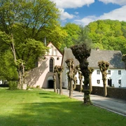
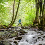
A real experience: walking around the Wahnbachtahlsperre, through numerous small gorges and stream valleys and over wooded hills! Your efforts an the challanging tour will be rewarded again and again with fascinating views over the Wahnbachthalsperre. In between, you can relax on comfortable hinking loungers with a view and learning interestig facts about the products of drinking water.

Good to know

Best to visit

suitable
Depends on weather

Directions

The route, which is over 20 kilometers long, is a challenge even for experienced hikers because of its sometimes very narrow trails and the constant ups and downs! At the dam, you may have another opportunity to fill your water bottles with freshly treated reservoir water. After crossing the dam, the path starts up the mountain. First, a forest path leads you past the trees and meadows of Happerschoß, then it goes back into the forest: under large trees you reach the first stream valley. Two stream crossings later, the route now leads you uphill again to the picturesque half-timbered village of Pinn. Natural paths show the way down the valley, and on the way you can enjoy the view over the clear water of the reservoir at a hut at the Ringelstein lookout point. The path then leads towards Wolperath, from where the forebay of the dam can already be seen. After crossing the northern foothills of the dam, a path leads over a narrow ridge between sparse oaks and pines to the west side. Here the path continues to wind around the numerous tributaries and frequently crosses narrow V-shaped valleys. At the level of the village of Schneffelrath you leave the banks of the dam. After crossing the Derenbach valley, a quiet asphalt road leads through a tranquil walnut tree avenue towards Gut Umschoß. Below the estate, an old orchard offers the opportunity to end the day on a lovely lounger with a "lake view".

Tour information

  • Loop Road

Equipment

Sturdy shoes and weather-appropriate clothing

Directions & Parking facilities

A3 to exit Siegburg Nord - on B484 direction Siegburg - after taht take B56 direction Much
Parking lot at the dam. Alternatively: hiking parking lot in Wolperath (Neunkirchen-Seelscheid)
Line 510 (VRS) from train station Siegburg or Hennef, train stop Seligenthal


current departure times stop Seligenthal

Additional information

Stamping point: Waldliege am Ringelstein/ Schutzhütte


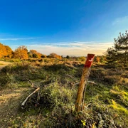
The "Erlebniswege Sieg" are completely marked with the red logo. You can find boards with overview maps and further information on places to stop and stay overnight as well as on places of interest at the starting point of each adventure trail.

Literature

Author

Naturregion Sieg

Organization

Rhein-Sieg Tourismus

License (master data)

License: Attribution, ShareAlike

Author´s Tip / Recommendation of the author

in some sections of the route, challenging route on narrow and steep paths

Map

Nearby

Contact

Erlebnisweg Sieg | Talsperrenweg | Siegburg
53721 Siegburg