


- 2:30 h
- 5.85 km
- 150 m
- 149 m
- 77 m
- 186 m
- 109 m
- Start: Hiking car park Stein, Am Burghardt, 53773 Hennef
- Destination: Hiking car park Stein, Am Burghardt, 53773 Hennef
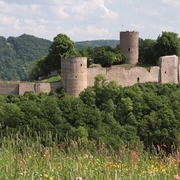
Easy and varied route with enough time for sightseeing, stops, or relaxation: while strolling through the medieval town and exploring the Blankenberg castle complex, you'll find plenty of information about history. On the short circular route, you also enjoy spectacular views of the Sieg valley, cross a primeval creek valley, and discover a mysterious throne. A perfect beginner's route!
Good to know
Best to visit
Directions
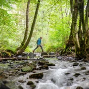
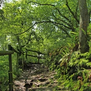
From the Stein hiking car park, you first go over a meadow path up to a mountain ridge with a breathtaking view of the Blankenberg castle complex. A somewhat windy day provides a special experience at the "Sound Throne." A narrow path leads down to fish ponds and the nature reserve "Ahrenbachtal and Adscheider Tal." Under ancient oak trees, you follow a natural creek floodplain. Woodpeckers and robins live here, and in summer dragonflies glide over the water. A meadow path leads to a short asphalt section, which you walk up to the height, where it continues on a field path. On the high meadows and pastures along the way, fruit trees grow and sheep and goats graze. In earlier times, the Burgberg’s vineyards stood here. Through the imposing Katharinentor gate, you reach the town of Blankenberg – today a district of Hennef that has preserved its medieval charm with its half-timbered houses and winding alleys. Past the marketplace, you leave the town again and walk toward the castle ruins. From a viewing point above the steeply sloping hillside, you have a great view over a curve of the Sieg and learn exciting details about the formation of the landscape. Surrounded by walls and hillside meadows with old fruit trees, the path leads back toward the starting point. Let your gaze wander: the Sieg valley shows itself here in its picture-book side. Down steep paths and stairs, you come back to the Stein hiking car park.
Tour information
Cultural Interesting
Familiy-Friendly
Loop Road
Equipment
Sturdy footwear and weather-appropriate clothing
Directions & Parking facilities
S-Bahn stop Blankenberg (Sieg): lines S12 and S19
Additional information
Show Burgweg in outdooractive.
Stamp point: hiking information board at Katharinentor
The Experience Trails Sieg are fully marked with the red logo. Stands with overview maps and further information about dining and accommodation options as well as sights can be found at the starting points of each experience trail.
Literature
Author
Naturregion Sieg
Organization
Rhein-Sieg Tourismus
License (master data)

Author´s Tip / Recommendation of the author
Between the villages of Adscheid and Stein, spectacular views of the castle and Sieg valley. A visit to St. George's Tower and the castle ruins is definitely worthwhile. Note: closed on Mondays and in winter.
Map
Nearby