


- 4:00 h
- 13.26 km
- 200 m
- 200 m
- 87 m
- 235 m
- 148 m
- Start: Eitorf train station
- Destination: Eitorf train station
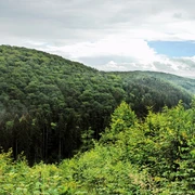
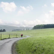
Just like back then: sheep pastures, rustic forest and meadow paths with lonely wayside crosses, half-timbered villages among scattered orchards. The idyllic villages route runs across the gentle heights of Leuscheid and offers you beautiful distant views. Back in Eitorf, numerous places to stop for a meal await.
Good to know
Best to visit
Directions
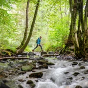
The starting point for the circular route is Eitorf train station. The short section through the city center offers good opportunities to stock up on some provisions. The route then follows the Eipbach – a lively stream that powered the traditional "Baust Mill" in the 19th century. At the former mill building, the path leaves the city center: idyllic sheep pastures set the nostalgic theme of the hike. After changing sides of the slope, the ascent begins with a long path through lush deciduous forest below the Eitorf golf course. To reach the extensive Mierscheid heights, you cross the country road in the valley of the Eipbach and hike steadily uphill on a historic connecting path. A nice contrast is offered by the subsequent route along lonely lanes and field paths through gentle pastureland with orchards and rustic half-timbered villages. Up here you enjoy numerous picturesque views. Afterwards, a bright section with pine trees provides fresh forest air, blueberries line the path, and a romantic pavilion offers a resting spot – the highest point of the hike is reached. Going downhill again, a narrow path winds in tight switchbacks over soft forest floor past the mysterious standing stones towards Eitorf. Following the view into the Sieg valley, it continues between gnarled pasture fences back into town. On the way back to the station, Eitorf shows its green side once again – the historic park "Siegpark" dates from the Gründerzeit period.
Tour information
Familiy-Friendly
Loop Road
Equipment
Sturdy footwear and weather-appropriate clothing
Directions & Parking facilities
A 560 towards Hennef, exit Hennef (East) – L 333 towards Eitorf.
P+R Eitorf West/train station (215 parking spaces), Am Viehof 5, 53783 Eitorf
P+R Eitorf East/train station (140 parking spaces), Brückenstraße 29, 53783 Eitorf
Additional information
Stamp station: Mierscheid shelter
The Experience Trails Sieg are fully marked with the red logo. Displays with overview maps and further information on dining and accommodation as well as sights can be found at the starting points of each Experience Trail.
Author
Naturregion Sieg
Organization
Rhein-Sieg Tourismus
License (master data)

Author´s Tip / Recommendation of the author
also attractive for hikers new to the activity
route suitable for "hiking with dogs"
Map
Nearby