- 2:00 h
- 5.56 km
- 119 m
- 119 m
- 103 m
- 222 m
- 119 m
- Start: Bourauel hiking car park, Eitorf
- Destination: Bourauel hiking car park, Eitorf
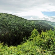
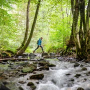
An extraordinary experience in the open countryside: blooming, fragrant meadows buzzing and humming. On a solitary country road, you cross the eco-niche of the bright Mengbachtal – afterwards you have the opportunity for an extensive picnic on a meadow with a great view after a forest passage.
Good to know
Best to visit
Directions
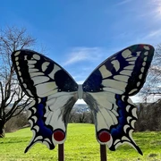
Your route starts directly on an idyllic country road along a row of fragrant meadows through the quiet Mengbachtal. Here, the eponymous stream bubbles cheerfully through the small valley kept open by regular mowing. The route leads gently uphill; venerable oaks line the path. In summer, the air is full of bird songs and butterflies add colorful touches. Through a forest section shaped by reforestation, a narrow forest path takes you to the "Gecksbitze." On the ridge, you will discover a solitary orchard surrounded by deciduous forest. After a few hundred meters of forest path, an extensive sunny hillside meadow offers a chance for a long rest. There, the small Storcker hut invites you to a picnic. From here, the view stretches far over the meadows down to Eitorf and to the forested heights of the Leuscheid. Before you soon reach the starting point again on a quiet asphalt road, an orchard follows another on the last downhill section. The trees in the meadows bear different, partly old fruit varieties and are considered valuable biotopes: according to experts, up to 5,000 different plant and animal species live on an orchard meadow!
Tour information
Familiy-Friendly
Loop Road
Equipment
Sturdy footwear and weather-appropriate clothing
Directions & Parking facilities
A560 with connection to L333 to Bourauel – in Bourauel Hohner Weg towards Hohn, hiking car park in a tight left curve on the right side
Bourauel hiking car park
Eitorf (Sieg) Train Station: RE 9, Line S12 and S19
From here it is 2.5 km to the Bourauel hiking car park.
Current departure times Eitorf Train Station
No direct bus connection to the Bourauel hiking car park
Line 570 (VRS) from Eitorf station, stop Eitorf Untenroth
From here it is approx. 24 min on foot (1.9 km): From "Am Erlenberg" northwest towards "Zum Bergwerk", turn right onto Harmoniestraße, turn left onto L86 and cross the Sieg bridge to Bourauel, turn left and continue straight on Bouraueler Straße, turn right onto Hohner Weg and later right to the Bourauel hiking car park
Additional information
Stamp station: Natursteig bench above Bourauel
The Experience Trails Sieg are fully marked with the red logo. Displays with overview maps and further information on eating and accommodation options as well as sights can be found at the starting points of each experience trail.
Literature
Author
Naturregion Sieg
Organization
Rhein-Sieg Tourismus
License (master data)

Author´s Tip / Recommendation of the author
Tip for children: photo safari along the wild meadow trail; fotosafari@naturregion-sieg.de.
Route suitable for "hiking with dogs"
Map
Nearby