Friendship Route Saxon-Bohemian Switzerland


- 12:25 h
- 40.97 km
- 974 m
- 974 m
- 223 m
- 482 m
- 259 m
- Start: On the German side: Kräuterbaude Saupsdorf
- Destination: On the German side: Kräuterbaude Saupsdorf
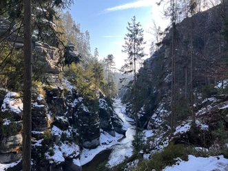
The Friendship Route Saxon-Bohemian Switzerland between Hinterhermsdorf and Jetřichovice combines about 42 km of scenic heights with the impressive rock landscape in the Saxon Switzerland National Park and the Czech National Park Národní park České Švýcarsko. A boat ride in the Kirnitzsch Gorge is also possible!
The path runs in the shape of a figure eight with a loop on the German and a loop on the Czech side of the border crossing Hinterdittersbach/Zadní Jetřichovice. On both sides the loops can of course also be hiked as day routes. Overnight accommodations for the two-day hike include the partner accommodations: on the German side the Kräuterbaude Saupsdorf and the Thorwaldblick campsite in Hinterhermsdorf, on the Czech side the Wellness Hotel Zámeček in Rynartice and the former sanatorium in Jetřichovice. Parking is also available at the partners.
Good to know
Pavements
Best to visit
Tour information
Cultural Interesting
Loop Road
Loop Road
Stop at an Inn
Author
Amrei Voigt (NLPFV)
Organization
Nationalpark Sächsische Schweiz
License (master data)
Amrei Voigt (NLPFV)

Nearby


Download GPX file