


- 3:00 h
- 43.06 km
- 430 m
- 452 m
- 125 m
- 382 m
- 257 m
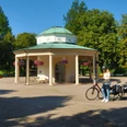
- Start: ADFC Station Bad Meinberg - Brunnenstraße 67
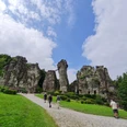
- Destination: Externsteine, Hermannsdenkmal, Detmold.
First to the Externsteine and then on natural paths through fields, forests and meadows steeply up to the "Hermanns-Denkmal" on the Grotenburg. The very steep return route leads to the Donoper Teich nature reserve, the old town of Detmold and along the Werre to Bad Meinberg.

Good to know
Pavements
Best to visit
Directions
We start at the ADFC station in Bad Meinberg, follow "Brunnenstraße" to the right, keeping to the NRW cycle route signs for "Horn", left into "Krumme Straße", right into "Allee", and at the traffic circle straight ahead into "Bahnhofstraße". The signs lead us over the "Kreuzenstein" into the industrial and commercial area of "Bahnhofstraße", later the NRW cycle signs "Externsteine / Fürsten-Radroute" lead us into "Mittelstraße" through the old town of Horn, later "Paderborner Straße" and to the right into "Jahnstraße". We cycle through the housing estate, turn right into "Schützenstraße", in the left-hand bend we follow the cycle signs straight ahead into the narrow forest path, which ends on the access road to the large Externsteine parking lot. - km 7 - The route leads slightly uphill from the parking lot to the Externsteine Information Center with its permanent exhibition.
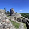
The wide natural road leads us directly to the rock formation and in between with the familiar signs in the direction of "Holzhausen". At the end of the lake, we come straight ahead onto the asphalt cycle path "Fürsten-Radweg / Senne-Radweg / Römer-Radweg / D-3-Netz / Europa-Radweg R1", cycle in a right-hand bend on this through the forest to the outskirts of Holzhausen and further on "Am Bärenstein", left into "Schliepsteinweg", left into "Lange Straße" to the lowest point of the village. Now turn left onto the asphalted farm track "Am Kral", signposted "Berlebeck", and continue steadily uphill, later enjoying a wonderful view of the Hermann monument from the hilltop. The cycle path markings guide us through the meadows down to Berlebeck, where we turn right at the junction with Fromhauser- / Paderborner- Straße with pedestrian traffic lights onto the accompanying cycle/footpath. Our main route now follows "Paderborner Straße" to the next crossroads, at the traffic lights - km 15 / 160 m/NN - we turn left into "Denkmalstraße" and follow the accompanying cycle/footpath uphill to the farm with the house number "1933", here we leave the cycle path signposting and turn right into "Plaßkampweg". The asphalted field path leads through the farmstead and leads us slightly uphill to the last house, shortly afterwards we turn right into the forest and now follow this hiking trail. After approx. 500 m, this leads into a wide forest path at an acute angle. We keep left with the hiking trail markings "A 1" and the path climbs more steeply. After two short 15% gradients, we reach the "L828" with the NRW cycle signposts "Senne-Radweg / Hermannsdenkmal" at the small parking lot, here we keep right and follow the "L828" uphill on the accompanying footpath. - approx. 20 % gradient, push the bike for 150 m !!! -- . Before we reach the large parking lot, we turn right onto the wide forest footpath (access to the forest stage area) and now follow it first left, later keeping right around the hilltop of the Grotenburg. This leads directly onto the main tourist trail at the foot of the Hermann monument. - km 20 / 386 m/NN -
Alternative descent through the forest: On the "Denkmalstraße" to the small parking lot and in the right-hand bend of the country road, turn right onto the forest path, which leads directly down into the Heidental without traffic. At the end of the valley, follow the Heidentalweg to the left.
Exit via the country road: We leave this busy place via the exit of the parking lot and follow the country road to the left in the direction of "Hiddesen" - NRW cycle signs "Senne-Radweg / Römer-Radroute". Attention ! The next 2.5 km are quite steep downhill, at the end of the downhill section in the serpentine bend on the outskirts of Hiddesen we turn left into the unmarked "Heidentalweg"
.The asphalt road leads us in a large bend through the quiet forest and meadow valley past three individual standing buildings to the wooded opposite slope, here we keep straight ahead with the hiking trail signs "HERMANNSHÖHEN" onto the roughly gravelled forest path, which leads over a small hilltop to the busy country road "Lopshorner Allee - L938". Cycle along the narrower HERMANNSHÖHEN hiking trail to the Krebsteich pond and follow the stream to the left to the Donoper Teich . - km 26 / 160 m/NN -
From the weir, cycle out of the valley on the rough dirt road past a single building, keeping uphill behind it in the forest to Kupferberg. The forest path later joins the "Kiefernweg", on this asphalt road we cycle downhill to the "Plantagenweg" and cross this straight ahead into the "Waldstraße". After approx. 500 m, the "Birkendamm" with the NRW cycle path signposting "Detmold / Fürsten-Radroute" crosses our quiet residential street, we turn right and follow the signs through the suburb of Heidenoldendorf. The "Birkendamm" joins "Bielefelder Straße" at a set of traffic lights, we are guided along the main road to the traffic lights, where we turn left into "Heidenoldendorfer Straße", follow the road to the traffic lights at the employment office and here we keep right into "Elisabethstraße". At the end of the street, turn right into "Hermannstraße", second left into "Gerichtsstraße", straight ahead into "Bruchstraße" and at the Schloßgraben turn left into "Ameide" until you reach the Lippisches Landestheater. - km 33 / 135 m/NN -
The way back to Bad Meinberg now leads us into the street "Rosental" with the NRW cycle path signposting "Werre-Radweg / Bad Meinberg". We cross the pedestrian zone "Lange Straße" and turn right before the Werre bridge into "Friedrichstraße", which leads into "Leopoldstraße". We cross the inner city ring road and follow the NRW cycle signs to the Aqualip leisure pool on Georg-Weerth-Straße. We ride past the large swimming pool, come to a pedestrian cycle path and cross under the railroad line at the end. Directly after the underpass, we turn right onto the narrow footpath/cycle path "Werre-Radweg" and follow this - at the junction we keep right - cross the Werre on a narrow bridge and come to "Talstraße". At its end, we push our bike over the pedestrian bridge "Hornsche Straße", right the cycle path leads us in the direction of Remmighausen.
We cross this busy main road at the next set of pedestrian lights at Dreierkrugplatz and turn left into Sporker Straße, which is signposted with the NRW cycle path Werre-Radweg. On the far bank of the Werre, the route climbs briefly, then this quiet residential road leads past several farms and at the end of the residential area leads into "Remmighausener Straße". --km 37--
We follow the cycle path to the right, roll down the hill until shortly before the Werre bridge, the busy road is now crossed and we cycle along the "Schönemarker Weg" through the wide fields of the Werre valley. At "Lenstruper Weg", we turn right and then follow "Wilberger Straße" to the left. The following ascent is leisurely through the fields up to the hilltop above Wilberg. After a short, steep descent, we keep left onto the cycle path along the B 239 towards Bad Meinberg. The last ascent of the tour is quickly completed and we cycle down to our destination, turn left at the traffic circle into "Allee", follow the signs for "Fahrrad-Vermietung" into "Krumme Straße", "Brunnenstraße" and after 43 km we have reached the starting point again.
Rest stops: Bad Meinberg, Horn, Externsteine, Hermannsdenkmal, Hiddesen, Detmold.
Equipment
Directions & Parking facilities
Additional information
Literature
Author
Oksana Schilke
Organization
GesUndTourismus Horn-Bad Meinberg GmbH
License (master data)
Oksana Schilke

Author´s Tip / Recommendation of the author
Safety guidelines
Note: This tour suggestion is suitable for particularly sporty and enduring cyclists. A bike with at least 14-speed derailleur gears and a helmet are strongly recommended. The route profile is very hilly with three longer steep sections. Most of the route is asphalted. The forest path up to the Hermanns monument and in the Donoper Teich area is a wider natural and gravel path.
Alternative descent without a lot of traffic: The alternative route on the forest path into the Heidental valley. From the WALK tourist information office via the large parking lot to Denkmalstraße. Descend on this road with a 20% gradient - same route as the approach route - to the end of the small hikers' parking lot. At the next right-hand bend in the road, turn right onto the forest path and follow it down into the Heidental valley. There you will meet the route of the tour description or the track again.
Map
Nearby