- 2:00 h
- 8.22 km
- 57 m
- 58 m
- 718 m
- 759 m
- 41 m
- Start: Holzkirchen - Großhartpenning sports field
- Destination: Holzkirchen - Großhartpenning sports field
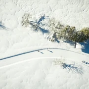
The starting point is the sports field in Großhartpenning, where parking is also available. Those coming from the north will be surprised by how much snow lies in the 'snow hole' Großhartpenning. The trail mostly runs level and only slightly ascending in a large loop along the edge of the forest to the south of Kurzenberg in the south and Sufferloh in the north. The trails are easy to ski without steep gradients or inclines; moreover, they are often very wide groomed in both directions and prepared for both techniques - cross-country skiing fun for young and old, from beginner to professional is guaranteed. Depending on snow conditions, there are also small ascents and descents near the sports field groomed.
After cross-country skiing, the Alt- or Neuwirt in Großhartpenning or the Schreinerwirt in Kleinhartpenning invite you to stop for a meal.
The trail is groomed for skaters and classic cross-country skiers. Floodlight operation Tuesday and Thursday 7:00-9:00 pm.
The trails are closed for grooming from 6:00 pm.
Good to know
Best to visit
Tour information
Barrier-Free
Familiy-Friendly
Loop Road
Loop Road
Stop at an Inn
Author
Markt Holzkirchen Standortförderung
Organization
Alpenregion Tegernsee Schliersee
License (master data)

Nearby