HAAS Prefabricated Construction Trail at Schliersee


- 3:00 h
- 15.76 km
- 380 m
- 385 m
- 776 m
- 1,154 m
- 378 m
- Start: Schliersee
- Destination: Schliersee
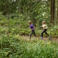
On almost 16 km, the demanding round requires quite a bit of stamina. About 400 m of elevation must be overcome before you can take the return path comparatively flat along the shore of Schliersee. The route is varied, initially leading out of Schliersee and into the forest at Westerberg before returning and running through Schliersee.
Good to know
Best to visit
suitable
Depends on weather
Tour information
Loop Road
Loop Road
Stop at an Inn
Author
Regionalentwicklung Oberland
Organization
Alpenregion Tegernsee Schliersee
License (master data)

Nearby

