Harz Border Route on the Green Belt


- 22:30 h
- 90.97 km
- 1,633 m
- 1,480 m
- 97 m
- 1,141 m
- 1,044 m
- Start: Rhoden Border Tower at Fallstein
- Destination: Border Museum Tettenborn/Bad Sachsa
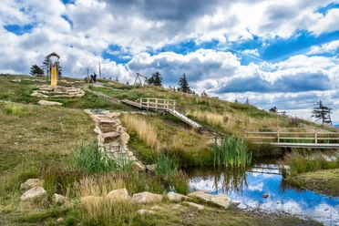
The Harz Border Route on the Green Belt, which for the most part runs directly on secluded border paths or the former "patrol road" along the former inner-German border, uniquely connects the nature, culture, and history of the Harz.
It crosses the mountain range on a varied and partly challenging hiking route between the Rhoden border tower (Osterwieck) in the north and the Borderland Museum Tettenborn (Bad Sachsa) in the south.
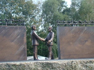
Along the way, you experience German contemporary history up close. Through the Ecker valley, a border river for many years, the path winds along the Ecker Dam – through the middle of which the border also ran – up to the Brocken. Past the Dreieckiger Pfahl, a historic tripoint marker, it goes below the Wurmberg to the border opening memorial stone between Braunlage and Elend. Relicts of the German division are preserved at the open-air border museum near Sorge. The Ring of Remembrance and the tripoint marker at Jägerfleck near Benneckenstein are contemporary border markers on the way to Walkenried Abbey, which offers a fascinating insight into the significance of the Cistercians for the region's development.
The Harz Club has fully signed the route. Information boards explain the protected biotopes and historical sites along the trail. For those wanting to learn more, specially trained hiking guides offer guided routes. Specialized tour operators also organize luggage-free hikes over various stages along the Harz Border Route.
Good to know
Best to visit
- suitableDepends on weather
Tour information
Cultural Interesting
Stop at an Inn
Summit
Author
Harzer Tourismusverband
Organization
Harz: Magische Gebirgswelt
License (master data)