In't Dörp (In's Dorf)


- 3:31 h
- 14.80 km
- 8 m
- 4 m
- 20 m
- 16 m
- Destination: Clüverhaus, Große Kirchenstraße 1
The formerly independent farming communities were incorporated into Achim in 1972 as part of an area reform. A village character can still be discovered in various places today. The circular tour begins in the "old village of Achim", leads along the Weser to Bollen, then back through Uphusen and along the "Sandtrockenrasen nature reserve".
Way description:
The hiking tour begins in the "Achim farmers' quarter" (1) at St. Laurentius Church (2). You will find the first hiking trail sign in the church parking lot. Now go down the steps in a southerly direction down "Kleine Kirchenstraße" and turn right into "Unterstraße" (3). Follow this street until you come to the street "Am Werder" (4), into which you then turn left. From the dyke, on which you can now walk, you have a rewarding view of the Achimer Marsch. You have now reached the district of Bierden (5) unnoticed. Behind the inn "Zur Linde", turn left into the street "Bierdener Marsch". Then continue to the right behind the dyke culvert. Follow the path until the dyke crosses your path. From here, the hiking trail follows the dyke (6) or the road along the dyke in the direction of Clüverswerder. You can enjoy the view of the Bierden marsh (7) and the Weser from the numerous benches. Here too, the marsh is part of the Clüverswerder nature reserve (8), which stretches from Verden-Eissel along the Weser to the Bremen area. The path continues past the Achim sewage treatment plant (in operation since 1965) to the point where the road running alongside the dyke branches off to the right. There you will find a refuge below the dyke. At this point, keep left and continue along the dyke. After a few meters, you will reach a lake framed by tall trees on your right. The Clüverswerder estate (9) can be glimpsed through the trees. The path continues along the top of the dyke. Past the "Pannen" marshland (10), the dyke comes within a few meters of the Weser river. From here you can observe the shipping traffic on the Weser very well. The campsite also takes you to the district of Bollen (11). From here, you can choose whether you want to walk on the soft surface of the dyke or on the asphalt road. You should pause for a moment at the dyke embankment and let your gaze wander over the marsh. The many wind turbines on the horizon are striking.
From the "Bollener Dorfkrug" you can take a detour to the Weser if you take the left-hand path at the crossroads.
If you want to continue walking straight away, turn right onto "Bollener Landstraße". At the next crossroads, turn right into "Bollener Dorfstraße". The path here leads through the Ackermarsch.
Shortly before the end of "Geestkampsweg", turn right onto the low summer dyke until you reach the Hilgenberg residential area (12), which belongs to the district of Uphusen (13)." At "Am Weserberg", turn right onto the road "Am See". On this path you will pass the "Sandtrockenrasen" nature reserve (14) and on your right is the Bierden cemetery, which was opened in the summer of 1989. Walk straight ahead along the road "In den Bergen" until you reach the dyke again. You return to Achim via Bierdener Marsch and the dyke, where you reach the starting point via "Unterstraße" and "Kleine Kirchenstraße".
Sightseeing/interesting facts:
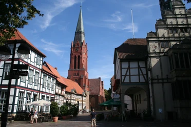
(1) Village of Achim:
The area with the historic St.Laurentius church and the surrounding buildings is known as the Achim farming district or the "old village of Achim". A total of 14 Bauhöfe (large farms) were farmed here, most of them until the 20th century. Historically, they are probably the oldest settlements in the village. Also worth seeing here is the Clüverhaus (Große Kirchenstraße 1), a typical Lower Saxon two-storey half-timbered farmhouse, which was rebuilt after a fire in the previous building in 1824 and later bought and restored by the town in the 1970s. Where people and animals once lived under one roof, an integrative café is now run. At the neighboring Meislahn farmstead (Kleine Kirchenstraße 2), some compartments with wickerwork have been reinstalled after restoration of the old half-timbered barn.
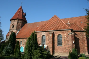
(2) St. Laurentius Church:
The building, first mentioned in a document in 1257, is the oldest structure in the town. The church served as a place of refuge in times of war and fire. Originally built as a Romanesque fieldstone building, the church was later extended to include two chapels. Worth seeing are the pulpit from 1631, the late Baroque altar from 1750 and a late Romanesque baptismal font. www.st-laurentius-achim.de, guided tour of the church: Achim Tourist Information Office, tel. (04202) 2949, www.achim.de.
(3) Former prison:
To the right is a house whose foundations are partly made of boulders. In the old days, the prison of the Achim court was housed here. There is a small plaque on the wall with information about this house.
(4) "Am Werder":
The street name (Werder = island) is a reminder that this part of Achim became an island when the Weser flooded.
(5) Village of Bierden:
The village of Bierden was mentioned in documents as early as 1059. Archaeological finds prove that it is an ancient settlement area. Originally, Bierden was purely a farming village, but it grew very quickly after the Second World War due to the influx of displaced persons. As a result of the changing times, the number of full-time farmers declined and commercial enterprises settled here instead. In 1972, the village of Bierden became a district of Achim as a result of the territorial reform.
Tip: An information board of the Achim local history association with the history of the village is located at the cyclists' rest area in Fahrenholzstraße/Auf dem Brink (approx. 350 m from the "Zur Linde" inn).
(6) Dike:
Due to its height, the dike is a special dry biotope with its own plant species. Wild bees and bumblebees dig their nesting tubes into the embankment.
(7) Bierden Marsh:
The marsh landscape here has largely retained its original character as a pasture marsh with hawthorn hedges and interspersed trees such as English oaks, ash trees, field maples and many other trees. Small bodies of water and ditches complete the habitat for wildlife. The call of the cuckoo can often be heard from afar.
(8) Clüversee:
A large colony of grey herons and rooks can occasionally be observed on the island in Clüversee. The breeding season for both species begins in April with nest building or nest repair and ends in early July when the last young herons fledge. The pond is home to coots and moorhens and, for some years now, a pair of Egyptian geese, which were originally zoo refugees and are now a permanent part of the landscape. In summer, sea frogs can be heard from afar.
(9) Gut Clüverswerder:
The Clüverswerder estate was once a moated castle well fortified with ramparts and moats. It belonged to the Clüver family, who had lived in Achim since around 1100. The last heir to the estate died in 1660 and it remained in Swedish hands until 1772. In 1772, the estate was bought by a citizen of Bremen.
(10) Marsh area "Pannen":
Towards Bollen on the right hand side is a small wetland, the so-called "Pannen", a refuge for water and marsh birds. The song of the nightingale can often be heard from the adjacent dense wooded strips in the early summer months.
(11) Village of Bollen:
First mentioned in a document around 1120 as "Bonlande", the village has been called Bollen (Middle German for "settlement on the hill") since 1515. Until 1914, farmers were able to cross to the other side of the Weser by ferry. Today, the idyllic village is characterized by the equestrian farms and offers numerous campers accommodation close to nature on the surrounding campsites directly on the Weser. Tip: Take a look at the information board of the Achim local history association with the local history opposite the "Bollener Dorfkrug".
(12) Hilgenberg residential area:
The name comes from Middle Low German and means "holy mountain". The Jacobi Chapel is said to have stood in an adjacent wood in earlier times.
(13) Village of Uphusen:
The village of Uphusen was first mentioned in 1219, but prehistoric finds suggest that the area was already inhabited 3000 years ago. Around 1900, a chain of dunes with mounds up to 20 meters high dominated the townscape. Due to industrial development, the sand hills and heathland disappeared.
(14) Sandy dry grassland nature reserve with Ellisee:
The area, which was declared a nature reserve in 1994, is part of a dune range that was formed by drifting after the Ice Age. The originally mighty chain of dunes stretched from Bremen-Lesum via Achim and Verden to Nienburg. The nutrient-poor dry sandy grasslands are now rare. They provide an indispensable habitat for specialized and endangered species such as wild bees, beetles and grasshoppers.
Lake Ellisee was named after the last owner of the former farming site on the lake, Elli Züwering, who many Uphuser residents remember as Kösters Elli. This small farm was founded in 1843 by Hinrich Köster as a lonely estate between Bierden and Uphusen on the old postal route from Bremen to Verden. And so it was only natural to call the nameless body of water created by the suction dredger after sand extraction "Ellisee". Over time, this name has also become part of official usage.
You can also find the tour at Komoot.
Safety information:
Way description:
The hiking tour begins in the "Achim farmers' quarter" (1) at St. Laurentius Church (2). You will find the first hiking trail sign in the church parking lot. Now go down the steps in a southerly direction down "Kleine Kirchenstraße" and turn right into "Unterstraße" (3). Follow this street until you come to the street "Am Werder" (4), into which you then turn left. From the dyke, on which you can now walk, you have a rewarding view of the Achimer Marsch. You have now reached the district of Bierden (5) unnoticed. Behind the inn "Zur Linde", turn left into the street "Bierdener Marsch". Then continue to the right behind the dyke culvert. Follow the path until the dyke crosses your path. From here, the hiking trail follows the dyke (6) or the road along the dyke in the direction of Clüverswerder. You can enjoy the view of the Bierden marsh (7) and the Weser from the numerous benches. Here too, the marsh is part of the Clüverswerder nature reserve (8), which stretches from Verden-Eissel along the Weser to the Bremen area. The path continues past the Achim sewage treatment plant (in operation since 1965) to the point where the road running alongside the dyke branches off to the right. There you will find a refuge below the dyke. At this point, keep left and continue along the dyke. After a few meters, you will reach a lake framed by tall trees on your right. The Clüverswerder estate (9) can be glimpsed through the trees. The path continues along the top of the dyke. Past the "Pannen" marshland (10), the dyke comes within a few meters of the Weser river. From here you can observe the shipping traffic on the Weser very well. The campsite also takes you to the district of Bollen (11). From here, you can choose whether you want to walk on the soft surface of the dyke or on the asphalt road. You should pause for a moment at the dyke embankment and let your gaze wander over the marsh. The many wind turbines on the horizon are striking.
From the "Bollener Dorfkrug" you can take a detour to the Weser if you take the left-hand path at the crossroads.
If you want to continue walking straight away, turn right onto "Bollener Landstraße". At the next crossroads, turn right into "Bollener Dorfstraße". The path here leads through the Ackermarsch.
Shortly before the end of "Geestkampsweg", turn right onto the low summer dyke until you reach the Hilgenberg residential area (12), which belongs to the district of Uphusen (13)." At "Am Weserberg", turn right onto the road "Am See". On this path you will pass the "Sandtrockenrasen" nature reserve (14) and on your right is the Bierden cemetery, which was opened in the summer of 1989. Walk straight ahead along the road "In den Bergen" until you reach the dyke again. You return to Achim via Bierdener Marsch and the dyke, where you reach the starting point via "Unterstraße" and "Kleine Kirchenstraße".
Sightseeing/interesting facts:
(1) Village of Achim:
The area with the historic St.Laurentius church and the surrounding buildings is known as the Achim farming district or the "old village of Achim". A total of 14 Bauhöfe (large farms) were farmed here, most of them until the 20th century. Historically, they are probably the oldest settlements in the village. Also worth seeing here is the Clüverhaus (Große Kirchenstraße 1), a typical Lower Saxon two-storey half-timbered farmhouse, which was rebuilt after a fire in the previous building in 1824 and later bought and restored by the town in the 1970s. Where people and animals once lived under one roof, an integrative café is now run. At the neighboring Meislahn farmstead (Kleine Kirchenstraße 2), some compartments with wickerwork have been reinstalled after restoration of the old half-timbered barn.
(2) St. Laurentius Church:
The building, first mentioned in a document in 1257, is the oldest structure in the town. The church served as a place of refuge in times of war and fire. Originally built as a Romanesque fieldstone building, the church was later extended to include two chapels. Worth seeing are the pulpit from 1631, the late Baroque altar from 1750 and a late Romanesque baptismal font. www.st-laurentius-achim.de, guided tour of the church: Achim Tourist Information Office, tel. (04202) 2949, www.achim.de.
(3) Former prison:
To the right is a house whose foundations are partly made of boulders. In the old days, the prison of the Achim court was housed here. There is a small plaque on the wall with information about this house.
(4) "Am Werder":
The street name (Werder = island) is a reminder that this part of Achim became an island when the Weser flooded.
(5) Village of Bierden:
The village of Bierden was mentioned in documents as early as 1059. Archaeological finds prove that it is an ancient settlement area. Originally, Bierden was purely a farming village, but it grew very quickly after the Second World War due to the influx of displaced persons. As a result of the changing times, the number of full-time farmers declined and commercial enterprises settled here instead. In 1972, the village of Bierden became a district of Achim as a result of the territorial reform.
Tip: An information board of the Achim local history association with the history of the village is located at the cyclists' rest area in Fahrenholzstraße/Auf dem Brink (approx. 350 m from the "Zur Linde" inn).
(6) Dike:
Due to its height, the dike is a special dry biotope with its own plant species. Wild bees and bumblebees dig their nesting tubes into the embankment.
(7) Bierden Marsh:
The marsh landscape here has largely retained its original character as a pasture marsh with hawthorn hedges and interspersed trees such as English oaks, ash trees, field maples and many other trees. Small bodies of water and ditches complete the habitat for wildlife. The call of the cuckoo can often be heard from afar.
(8) Clüversee:
A large colony of grey herons and rooks can occasionally be observed on the island in Clüversee. The breeding season for both species begins in April with nest building or nest repair and ends in early July when the last young herons fledge. The pond is home to coots and moorhens and, for some years now, a pair of Egyptian geese, which were originally zoo refugees and are now a permanent part of the landscape. In summer, sea frogs can be heard from afar.
(9) Gut Clüverswerder:
The Clüverswerder estate was once a moated castle well fortified with ramparts and moats. It belonged to the Clüver family, who had lived in Achim since around 1100. The last heir to the estate died in 1660 and it remained in Swedish hands until 1772. In 1772, the estate was bought by a citizen of Bremen.
(10) Marsh area "Pannen":
Towards Bollen on the right hand side is a small wetland, the so-called "Pannen", a refuge for water and marsh birds. The song of the nightingale can often be heard from the adjacent dense wooded strips in the early summer months.
(11) Village of Bollen:
First mentioned in a document around 1120 as "Bonlande", the village has been called Bollen (Middle German for "settlement on the hill") since 1515. Until 1914, farmers were able to cross to the other side of the Weser by ferry. Today, the idyllic village is characterized by the equestrian farms and offers numerous campers accommodation close to nature on the surrounding campsites directly on the Weser. Tip: Take a look at the information board of the Achim local history association with the local history opposite the "Bollener Dorfkrug".
(12) Hilgenberg residential area:
The name comes from Middle Low German and means "holy mountain". The Jacobi Chapel is said to have stood in an adjacent wood in earlier times.
(13) Village of Uphusen:
The village of Uphusen was first mentioned in 1219, but prehistoric finds suggest that the area was already inhabited 3000 years ago. Around 1900, a chain of dunes with mounds up to 20 meters high dominated the townscape. Due to industrial development, the sand hills and heathland disappeared.
(14) Sandy dry grassland nature reserve with Ellisee:
The area, which was declared a nature reserve in 1994, is part of a dune range that was formed by drifting after the Ice Age. The originally mighty chain of dunes stretched from Bremen-Lesum via Achim and Verden to Nienburg. The nutrient-poor dry sandy grasslands are now rare. They provide an indispensable habitat for specialized and endangered species such as wild bees, beetles and grasshoppers.
Lake Ellisee was named after the last owner of the former farming site on the lake, Elli Züwering, who many Uphuser residents remember as Kösters Elli. This small farm was founded in 1843 by Hinrich Köster as a lonely estate between Bierden and Uphusen on the old postal route from Bremen to Verden. And so it was only natural to call the nameless body of water created by the suction dredger after sand extraction "Ellisee". Over time, this name has also become part of official usage.
You can also find the tour at Komoot.
Safety information:
- Throughout the entire tour, please note that the paths are used at your own risk
- No guarantee is given for the usability of the paths
- In the cities/towns, increased attention is generally required
- On the tour, you must expect dangerous spots, such as bollards, barriers and unsecured crossings
Waypoints
Destination
Good to know
Best to visit
suitable
Depends on weather
Tour information
Familiy-Friendly
Author
Mittelweser-Touristik GmbH
Lange Straße 18
31582 Nienburg/Weser
Organization
Mittelweser-Touristik GmbH
License (master data)
Mittelweser-Touristik GmbH

Nearby