


- 5:00 h
- 16.09 km
- 570 m
- 570 m
- 404 m
- 653 m
- 249 m
- Start: Holthausen - Gasthof Vollmer-König
- Destination: Holthausen - Gasthof Vollmer-König
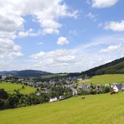
The hiking trail is challenging in some sections and requires a minimum time planning of five hours. You start in Holthausen at 490 m above sea level, descend to the lowest point of the hike at 407 m above sea level. With 658 m above sea level, the summit of Wilzenberg, you reach the highest point of the route. Wilzenberg is a cultural-historical place. Here is the pilgrimage chapel newly built in the 17th century, two refuge castles, the 28 m high summit cross, and the over one hundred years old 17 m high observation tower. From it offers a unique view over the "Land of a Thousand Hills." You look out over 19 of the 84 districts of the vast city Schmallenberg. Other villages from the neighboring town Winterberg with the Astenturm on the Kahlen Asten complete the panorama view. After climbing the tower, you hike down a short steep descent and then continue over further great hiking trails into the Lenne valley, through the gold village Niedersorpe, and finally back to the starting point. Before you reach it, enjoy again on about an 800 m long path stretch a wonderful panoramic view over more than half of the P.W. "Wilzenberg" you have hiked, the core city Schmallenberg, large parts of the Schmallenberger Sauerland, and our federal gold village Holthausen.
The hiking friends Holthausen-Huxel 1979 e.V. wish you a lot of fun hiking.
Good to know
Best to visit
Directions
Foreword:
The permanent hike of 8 km and 16 km is not marked with its own trail signs. Instead, we use the existing trail signs of the SGV and the distinctive directional signs of the Schmallenberger Sauerland hiking world. They consist of a square wooden post with attached metal plates. At the bottom edge, the signs are sometimes labeled with the location name but always indicate the altitude in meters above sea level. We use these orientation aids for the current location determination. They are listed in the further route description as "signpost location name" or "signpost altitude".
Route description 16 km:
We leave the starting venue and turn right, heading towards the bus stop. We follow the road out of the village. 50 m before the village exit sign, we see on the right at the junction the first "Signpost Holthausen Cemetery." We turn right and follow the hiking trail W2 towards Winkhausen. Upon reaching the main road in Winkhausen, we walk a short way along it towards the village until the road junction towards Niedersorpe. Immediately after the bridge opposite Hotel Deimann, we turn right at the pedestrian traffic light and follow the footpath, crossing the Lenne river and at the end of the path we turn right at the "Signpost 410 m." After 80 m we turn left and follow X27 and W1 uphill to the Wilzenberg.
At the next fork, we turn right and continue following the marking W1 towards Grafschaft. At Stellmecke, a large crossroads with a star signpost, we turn right and follow the marking A2 to the Wilzenberg hiking car park. From here we follow the marking A4 uphill, past the "Signpost Bleeding Savior" and further to the "Upper Wilzenberg" car park. Before the asphalt road ends straight ahead, we turn sharply left and continue uphill at the "Signpost Upper Wilzenberg Car Park," following the marking A4 to the chapel at Wilzenberg and the Wilzenberg tower.
From the "Signpost Wilzenberg Tower" we follow the marking O4 until we reach the Stellmecke junction again. From here we take the same path back down to Winkhausen and follow X27 behind Hotel Deimann. At the ponds in the hotel garden, we follow the Rothaarsteig trail (white lying R on a black background) uphill towards "Deimann’s Hut" and "Knollen Quarry." Behind the hut, the path leads uphill through the "Knollen Quarry" to the shelter "White Cross."
At the shelter, we turn left and follow N1 to Niedersorpe. Here we follow the hiking sign X13 through Niedersorpe to the Holthausen sports field. We continue with X13 uphill, turn around the barn and climb the short slope (100 m) to the "Signpost 536 m." From here we continue left with X13. After the barn on the right side of the path above Holthausen, we take the second turn left and go down into the village to our starting point.
Tour information
Cultural Interesting
Loop Road
Stop at an Inn
Summit
Equipment
Directions & Parking facilities
Bus lines: 464, 462, and 474, stop Kirchstraße (Holthausen) Schmallenberg
Timetable information: www.rlg-online.de
Additional information
The hike can also be done as an 8 km route. It then does not go over the Wilzenberg but returns from Winkhausen via Niedersorpe back to Holthausen.
To the 8 km hike "Holy Mountain" Wilzenberg.
The entry fee of 3 euros per participant includes the IVV stamp and insurance coverage. The hiking trail is insured against liability claims of third parties. The insurance coverage extends to the start and finish area and the specified hiking route. There is accident insurance for participants. This insurance applies to accidents occurring during the hike on the specified route, provided the participant is in possession of a valid start card which contains the participant’s full address. Liability for accidents outside the specified route is excluded. Start cards are available at Gasthof Vollmer-König (closed on Tuesdays).
Literature
Author
Wanderfreunde Holthausen-Huxel 1979 e. V.
Organization
Schmallenberger Sauerland Tourismus
License (master data)

Author´s Tip / Recommendation of the author
Enjoy the panoramic view over the Schmallenberger Sauerland from the Wilzenberg tower.
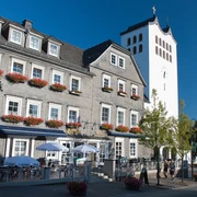
Visit the Westphalian Slate Mining and Local History Museum Holthausen with the South Westphalian Gallery. Opening days: Wednesday, Friday, and Saturday from 2:00 pm to 5:00 pm, and Sunday from 10:00 am to 1:00 pm.
Safety guidelines
Map
Nearby
