- 2:55 h
- 9.91 km
- 315 m
- 316 m
- 431 m
- 689 m
- 258 m
- Start: Hiking information Latrop - alternatively at the hiking parking lot
- Destination: Hiking information Latrop - alternatively at the hiking parking lot
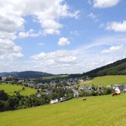
This beautiful and quiet circular route starts from Latrop and leads through the Schanze forest reserve.
Good to know
Best to visit
Directions
Always follow the hiking sign L2.
Tour information
Loop Road
Equipment
Directions & Parking facilities
From the BAB Olpe exit via Lennestadt to Fleckenberg. Here turn right for 7 km to Latrop.
From the east to Schmallenberg through the tunnel to Fleckenberg. In Fleckenberg, turn left at the intersection.
Free parking is available at the hiking parking lot in Latrop (at the end of the village).
In Latrop, bus line 466 operates, as well as line Ismo 466 (former hiking bus, must be booked at least 30 minutes before departure).
Timetable information: www.bahn.de
With a valid Schmallenberger Sauerland Card you can use public transport in the region free of charge.
Additional information
In Latrop, you can find the Country Inn Hotel Hanses-Bräutigam, the Hotel and Inn Hubertushöhe, as well as the Inn zum Grubental.
Author
Schmallenberger Sauerland Tourismus
Organization
Schmallenberger Sauerland Tourismus
License (master data)

Author´s Tip / Recommendation of the author
A visit to the small Forest Workers Museum in the old mill of Latrop is worthwhile.
Safety guidelines
An emergency point system is installed in the Hochsauerland district. You can find emergency points, among others, on the information boards at junctions and on the hiking signs.
Map
Hiking map Schmallenberg, scale 1 : 25,000
Hiking map Fleckenberg, Jagdhaus, Latrop, scale 1 : 29,000
Nearby