


- 7:30 h
- 25.08 km
- 532 m
- 532 m
- 146 m
- 302 m
- 156 m
- Start: Wissen station, 57537 Wissen
- Destination: Wissen station, 57537 Wissen
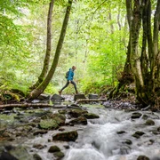
This is where your endurance is required: Circular route and longest stage of the Natursteig Sieg with moderate ascents and idyllic stream valleys. You hike on field, forest, and meadow paths – numerous distant views offer pleasant variety.
Good to know
Best to visit
Directions
The access path, like the final section of the previous stage, leads back to the main route uphill over Wissen. A relatively young and sparse forest accompanies the path on the left and right sides of the height, which is often deeply snow-covered in winter. Nearby is the Hagdorn farm with a playground and wildlife enclosure. Down into the valley of the Wisserbach, which on some days rushes powerfully along its course. The elevation above the Lauberbach offers a beautiful view of Birken-Honigsessen, which is soon walked through directly. The Catholic parish church St. Elisabeth, considered the first tent-roof church in Germany, is beautiful. Through a narrow valley gorge down to the quiet valley of the Wipperbach, up to Nochen and steeply down again into the valley where the Wipperbach and Brölbach unite. One last ascent to Kucksberg and then down to Wissen via a path that repeatedly opens views of the Sieg before reaching its valley floor and the yellow-marked access path to the train station.
©W&A Marketing & Verlag GmbH
Tour information
Loop Road
Stop at an Inn
Equipment
Sturdy footwear and weather-appropriate clothing
Directions & Parking facilities
Wissen (Sieg) train station: RE 9 and RB 90
Additional information
Stamp point: Forest bench with a view of Birken-Honigsessen
All stages of the Natursteig Sieg lead from station to station and are fully marked in both directions with the blue Natursteig Sieg logo. The access paths to quality hosts, town centers, and train stations are marked in yellow. Information boards with overview maps and additional hints on catering and accommodation options as well as sights can be found at the train stations and at the starting points of the stages.
Literature
Author
Naturregion Sieg
Organization
Rhein-Sieg Tourismus
License (master data)

Author´s Tip / Recommendation of the author
Parish church St. Elisabeth in Birken-Honigsessen (first tent-roof church in Germany)
Safety guidelines
Due to unstable beech trees on the steep slope above the B62, a parallel diversion route is signposted.
Map
Nearby

