


- 4:20 h
- 15.39 km
- 311 m
- 292 m
- 148 m
- 300 m
- 152 m
- Start: Wissen train station, 57537 Wissen
- Destination: Scheuerfeld train station, 57584 Scheuerfeld
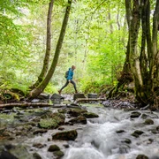
Surprisingly varied route with alpine paths high above the Sieg. The many paths are a real treat for trail enthusiasts! Rustic and wild – alternating with agricultural idyll, beautiful meadow paths and great panoramic views.
Good to know
Best to visit
Directions
From Wissen train station, the access path runs along the Sieg to the main trail. The Natursteig crosses to the right side of the river. The start is steep, uphill towards Schönstein and into the winding valley of the Firzelbach. Continuously uphill, at Blickhausen your first beautiful view of the surrounding heights opens up; shortly afterwards, you will discover a window into the past: a view over the slag heap of the Rasselskaute mine along with an information board teaches about the mining tradition of the region. Up and down it continues towards the campsite; along the way, you overcome a rope-secured steep section. Through the beautiful Osenbach Seifen valley, this stage reaches the Sieg, where a narrow footpath winds directly along the steep bank before climbing steeply up to the viewing rock “Steckensteiner Kopf” above the Sieg loop. First down, then up – a great contrast. There are always beautiful views into the rolling hinterland towards Mittelhof. Past the mobile home park, a sweeping path leads you through dense forest downhill to Scheuerfeld, which flashes through the leaves here and there.
©W&A Marketing & Verlag GmbH
Tour information
Stop at an Inn
Equipment
Sturdy footwear and weather-appropriate clothing
Directions & Parking facilities
Wissen (Sieg) train station: RE 9 and RB 90
current departure times Wissen train station
Scheuerfeld (Sieg) train station: RB 90
Additional information
Stamp station: Natursteig bench at Rodder Berg (Mittelhof)
All stages of the Natursteig Sieg lead from train station to train station and are fully marked in both directions with the blue Natursteig Sieg logo. The access paths to quality hosts, town centers, and train stations are marked in yellow. Information boards with overview maps and further information about dining and overnight accommodation options as well as sights can be found at the train stations and at the start points of the stages.
Literature
Author
Naturregion Sieg
Organization
Rhein-Sieg Tourismus
License (master data)

Author´s Tip / Recommendation of the author
• many paths through narrow valleys
• former Rasselskaute mine
• viewpoint Steckensteiner Kopf
Map
Nearby

