


- 3:30 h
- 11.21 km
- 365 m
- 369 m
- 192 m
- 434 m
- 242 m
- Start: Alsdorf station, 57518 Alsdorf
- Destination: Kirchen station, 57548 Kirchen (Sieg)
The Druidenstein is one of the most outstanding sights in the Naturregion Sieg. After the ascent via a pilgrimage path, you celebrate right at the impressive basalt cone “mountain festival”. High above the treetops, you enjoy the landscape panorama at the end of the route from the 18 m high Ottoturm.
Good to know
Best to visit
Directions
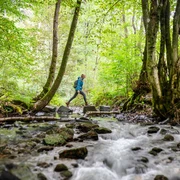
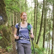
A short connecting path leads from Alsdorf station to the main path, which crosses the Heller and leads into the Imhäuser valley. It steadily goes uphill towards Herkersdorf, past fish ponds and moors. It soon becomes steeper, and here you gather all your reserves once more for the ascent to the Druidenstein. For a short stretch, the Natursteig Sieg accompanies the E1, which runs from Sweden to Umbria. A bit of wanderlust arises. Up the beautifully designed Way of the Cross, a pilgrimage route that depicts the Passion of Jesus Christ, you go uphill. Once at the top, it's time to admire the Druidenstein, an impressive basalt cone around which legends and myths revolve. You continue through a bright forest regeneration area towards Offhausen and into the valley of the Imhäuser stream, which you soon leave again. The Ottoturm, which towers over the 405 m-high Kahlenberg, challenges you to a final climb and delights you with a fantastic 360-degree view from 18 m high. Great! Fully satisfied and a bit further on, you leave the main path and follow the connecting path down to Kirchen station.
©W&A Marketing & Verlag GmbH
Tour information
Stop at an Inn
Equipment
Sturdy footwear and weather-appropriate clothing
Directions & Parking facilities
Alsdorf (Sieg) station: RB 97
current departure times Alsdorf station
Kirchen station: RE 9, RB 90 and RB 93
Additional information
Stamp location: bench next to signpost at the Druidenstein
All stages of the Natursteig Sieg run from station to station and are completely marked with the blue Natursteig Sieg logo in both directions. The connecting routes to quality hosts, town centres and stations are marked in yellow. Signposts with overview maps and further information about refreshment and accommodation options as well as sights can be found at the stations and at the starting points of the stages.
Literature
Author
Naturregion Sieg
Organization
Rhein-Sieg Tourismus
License (master data)

Author´s Tip / Recommendation of the author
• Way of the Cross to the Druidenstein
• the mystical Druidenstein
• Ottoturm with 360° view
Map
Nearby
