


- 6:00 h
- 19.93 km
- 600 m
- 575 m
- 190 m
- 491 m
- 301 m
- Start: Kirchen station, 57548 Kirchen (Sieg)
- Destination: Mudersbach station, 57555 Mudersbach
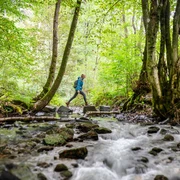
Typical Siegerland: mines, grottos, and tunnels along the way bring the centuries-old mining history of the region to life. The last stage of the Natursteig Sieg leads you over lonely forest paths to the medieval Freusburg high above the Sieg.
Good to know
Best to visit
Directions
©W&A Marketing & Verlag GmbH
Tour information
Stop at an Inn
Equipment
Sturdy footwear and weather-appropriate clothing
Directions & Parking facilities
Bahnhofstraße, 57548 Kirchen (Sieg)
P+R parking lot directly at Kirchen (Sieg) station
Kirchen station: RE 9, RB 90 and RB 93
current departure times Kirchen station
Mudersbach station: RB 90 and RB 93
Additional information
Stamp point: Natursteig bench at the lowest point between Freusburg and Hellbachskopf
All stages of the Natursteig Sieg lead from station to station and are fully marked in both directions with the blue Natursteig Sieg logo. The access paths to the quality hosts, village centers, and train stations are marked in yellow. Display boards with overview maps and further information about dining and accommodation options as well as sights can be found at the train stations and at the start points of the stages.
Literature
Author
Naturregion Sieg
Organization
Rhein-Sieg Tourismus
License (master data)

Author´s Tip / Recommendation of the author
• Freusburger Mühle
• Freusburg
• Giebelwald
Map
Topographic map 1:25,000, Northern Westerwald, sheet 3, ISBN 978-3-89637-252-9, €6.90
Nearby

