- Photos & Map
 How would you like to arrive?
- Description
 - Waypoints
 - Good to know
 - Nearby
 Download GPX file
- 2:00 h
 - 6.03 km
 - 150 m
 - 150 m
 - 468 m
 - 574 m
 - 106 m
 - Start: Royal Spa House Bad Elster
 - Destination: Royal Spa House Bad Elster
 
In Bad Elster, in addition to facilities for health and well-being, a variety of historic event venues and well-kept parks, there is also an attractive environment with a well-marked hiking trail network. These are special trails because they were laid out at the end of the 19th century as terrain cure paths, essentially as exercise routes for physical and mental training in nature.
The natural terrain structure offers the possibility to train with different stress levels. But factors such as the sun exposure of paths, landscape features, and attractive viewpoints were also taken into account. The nature experience was integrated into the healing process. Numerous resting areas and exemplary restored, well-maintained shelters and viewpoints still provide security to trainees and opportunities to rest, enjoy, and pause.
Waypoints
Good to know
Pavements
Best to visit
Directions
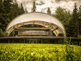
From the Royal Spa House, head east towards Brunnenberg, passing under the connection between the historic Albert Bad and the Soletherme. The Hotel König Albert is on your left; take a left at the barrier and then the narrow path behind the parking garage directly at the foot of Brunnenberg. At the large event board, take the path towards the NaturTheater, which gently ascends. Once there, you will see a historic music pavilion immediately beside the entrance of the NaturTheater, which has stood here since the late 1920s. Starting in 1928, the spa area was redesigned, and as a result, the music pavilion was relocated here, finding its place in the 'Clearing of Culture' within the forest park.
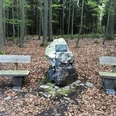
To the right of the music pavilion, a path leads uphill; follow it along the fence of the NaturTheater to the height of the historic box offices within the NaturTheater grounds. Now take the path uphill to the right, which branches off here, until you see some white quartzite stones at the next junction. This is volcanic rock, exposed by the weathering of the soft phyllite from which Brunnenberg is made. Here we turn left and already see the forest house, a small shelter first built around 1900. After a few meters, you reach a path that leads down into the valley. It joins the Mühlhausener Kirchsteig near the restaurant 'Waldquelle', but we leave it again after a few meters. Two stone pillars of the former old fence around the NaturTheater mark the spot where the Rundschauweg (green triangle) branches off to the right. Also visible here is one of the old toilet huts that were once scattered throughout the Brunnenberg forest.
Follow the Rundschauweg uphill until the forest opens up to a wide view towards Adorf, Mühlhausen, and Landwüst. This view was the reason for the construction of the Rundschau hut, of which sadly only two stone tables remain by the path. Continue uphill. Where it meets the Mühlhausener Kirchsteig today stands a new log cabin-style hut — the Alberti hut — instead of the original simple shelter. It was built in honor of bath director Oskar von Alberti, who worked in Bad Elster from 1904 to 1929 and to whom Bad Elster owes much.
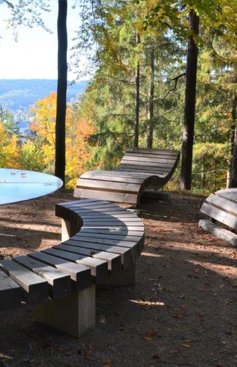
Several paths meet here. Take the Mühlhausener Kirchsteig to the right (green cross). About 200m along this path (marked by a green bench), turn left and reach the Wacholderhübel (see Genusswandern 2). Follow the path uphill to the Kreuzkapelle (also see Genusswandern 2), then continue straight to the Almweg (yellow cross), which you follow right down into the valley. To the left of the path is a newly designed very beautiful resting place with a large table and curved loungers, the Waidmannsruh. Here was once a weather vane that could be seen from the spa area. The path continues downhill to the Eremitage shelter. With a view of the Eremitage, two paths lead right. Please use the upper one and shortly after arrive at the Cotta terrace, a point offering an impressive view of the center of Bad Elster, which now lies directly below you. From here, descend the stairs and continue left, where you reach the last stop, the Bettybank, another lovely viewpoint with a shelter. To get to the town center or the starting point of the hike, you can use the stairs or one of the paths down into the Historic Spa Park, directly below you. From there, go to the spa area towards the König Albert Theater, cross the Fischbrücke bridge over the White Elster, and you will see the Royal Spa House a little further to the right on the opposite side of the street.
Tour information
Cultural Interesting
Loop Road
Stop at an Inn
Tour with Dog
Directions & Parking facilities
Bad Elster is accessible from the A72 - Plauen South exit, then follow the B92 to the turnoff for Bad Elster. From Bavaria, you can alternatively take the A93 to the Regnitzlosau exit. Drive towards Oelsnitz until just past the Saxon-Bavarian state border and turn right behind Posseck towards Adorf. Finally, you reach Bad Elster via the B92.
In Bad Elster, there are sufficient public parking spaces available (both paid and free) → info here: www.chursaechsische.de/besucherservice/anreise
Information about travel by bus and train is available from the Vogtland Tourism and Transport Center at 03744 / 19449 or at www.vogtlandauskunft.de
You can reach Bad Elster by Vogtlandbahn. Information about schedules and prices is available at www.vogtlandbahn.de
or from the Vogtland Tourism and Transport Center at 03744 / 19449 or www.vogtlandauskunft.de
Additional information
Bad Elster Tourist Information in the Royal Spa House
Phone 037437 53900
https://badelster.de/touristinformation
Events overview: https://chursaechsische.de/veranstaltungen/veranstaltungskalender
Various dining options are available in the Royal Facilities Bad Elster
Literature
Brochure 'Pleasant Hiking Bad Elster' The Royal Hiking Nature Paradise
available at the Bad Elster Tourist Information
Author
Vogtland - Sinfonie der Natur
Organization
Vogtland - Sinfonie der Natur
License (master data)
Author´s Tip / Recommendation of the author
an extensive forest bath at the Waidmannsruh rest area
a visit to an event at the NaturTheater Bad Elster
Map
Bad Elster city map with all hiking trails by Verlag Dr. Barthel
ISBN: 978-3-89591-239-9, 6th edition
Hiking, ski, and cycling map Vogtland Music and Spa Region, Bad Elster, Markneukirchen
ISBN: 978-3-89591-021-0, 7th edition
available at the Bad Elster Tourist Information
Nearby