- 1:22 h
- 18.37 km
- 89 m
- 89 m
- 82 m
- 106 m
- 24 m
- Start: Wiemenkamp parking lot, Delbrück
In the flat Delbrücker Land, the leaning church tower of the Romanesque parish church of St. Johannes Baptist announces the town center from a great distance. In addition to the church, the historic church square with its pretty half-timbered houses is also well worth a visit.
In Delbrück, the three "Ks" are written in capital letters, because tradition is very important. The three "Ks" stand for Kreuztracht, Katharinenmarkt and Karneval. The annual veneration of the cross has been taking place since 1496. The St. Catherine's market was first held in 1610 and the "Eintracht" Delbrück carnival club was founded in 1832, over 175 years ago.
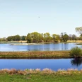
In terms of its origins and development, it can be said that Delbrück-Mitte in its current form was created in 1964 from the merger of the previously independent municipalities of Delbrück, today's town center, and Dorfbauernschaft, the entire outer area. The rapid development of the town after the war led to the creation of numerous new residential areas and industrial estates, which led to the establishment of trade and industry.The starting point of the approximately 19 km long tour is the Wiemenkamp parking lot. From there, follow the Bösendamm and Lerchenweg towards Nordhagen. Follow the signposts to reach the first points of interest on this tour. In addition to the former windmill at Walde and the burial mounds at Westerrellerhof, these include the Reller Chapel. After the old chapel was completely destroyed by a lightning strike, the current chapel was rebuilt in 1869. The site is a historical place of worship, where important trade and postal routes used to converge and where the "Reller market" took place. The Rellerbrink, an elevation around the chapel, is the old meeting place of the Delbrücker Land.The tour continues along Kiefernweg and Linnenstraße along the Haustenbach stream back towards the center of Delbrück. The Haustenbach is one of the Senne streams, which are often higher than the landscape they flow through due to the sand they transport. Past the cross at the end of Stettiner Straße, which was erected to commemorate the execution site of the Delbrücker Land, you reach the Boker Canal.
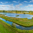
The Boker-Heide Canal is named after the village of "Boke" and is one of the most important technical cultural monuments in Westphalia. It stretches 32 km from Paderborn-Schloß Neuhaus via Delbrück to Cappel near Lippstadt, where it flows back into the River Lippe. From around 1850 until the mid-1970s, it was used as an irrigation canal to create a new livelihood for the impoverished population. With the help of 16 main sluices, numerous secondary canals, irrigation and drainage ditches, meadow and arable crops were made possible on the originally barren heath sand soils.Today, with its sluices and long rows of trees, it is an important feature of the landscape and is ideal for walking and cycling. From here, you return to the starting point of the circular route via the Wiesenweg and Boker Straße. Explore not only the landscape and historical sights on this tour, but also experience the diversity of Delbrück's retail trade.
Of course, along the entire tour, the typical local gastronomy along the way invites you to linger with changing seasonal dishes.
Good to know
Pavements
Best to visit
Directions
Tour information
Familiy-Friendly
Loop Road
Stop at an Inn
Directions & Parking facilities
via B64 from Rietberg: at the intersection (Red-Zac Markt/ Autohaus Schniedertüns) turn left into Boker Straße past the Stadthalle, the parking lot is on the left
Always know what's running: The smart number for buses and trains in NRW 01803 504030 (timetable information for €0.09/min from a German landline, mobile max. €0.42/min).
Additional information
Literature
Author
Ricarda Steiling
Organization
Stadt Delbrück / Stabstelle Öffentlichkeitsarbeit/Stadtmarketing/Wirtschaftsförderung
License (master data)
Ricarda Steiling

Author´s Tip / Recommendation of the author
Safety guidelines
Map
Nearby