Ralbitz-Rosenthal - Route 5


- 1:30 h
- 4.33 km
- 4 m
- 4 m
- 139 m
- 143 m
- 4 m
- Start: Parking lot Main Street/Seidau, 01920 Ralbitz-Rosenthal, OT Ralbitz
- Destination: Parking lot Main Street/Seidau, 01920 Ralbitz-Rosenthal, OT Ralbitz
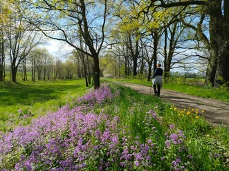
A pleasant route through the Lasker Auwald and over well-passable field paths in the middle of the Sorbian settlement area.
The bilingual community of Ralbitz-Rosenthal is located in the core area of the Sorbian-speaking Lusatia. Many, especially Sorbian traditions and customs, are lovingly maintained in the villages.
In Rosenthal there is a Marian pilgrimage site, which was cared for by Cistercians until 2007. Several pilgrimages take place annually on the pilgrimage meadow, including that of the Dresden-Meissen Diocese. The pilgrimage site Rosenthal is one of the five pilgrimage sites that have been united in the association "Central European Pilgrimage Sites" since 2000.
The start and end point Ralbitz is nationally known for its listed cemetery. White wooden crosses on each grave form symmetries and symbolize the equality of all people before God.
Good to know
Pavements
- Unknown (11%)Street (5%)Asphalt (4%)Gravel (20%)Trail (34%)Path (27%)
Best to visit
- suitableDepends on weather
Directions
- The route starts directly at the listed cemetery in Ralbitz and then leads over a pleasantly paved field path westwards to the Lasker Auwald.
- Through the Lasker Auwald you reach Laske.
- Past the village pond the route now leads southwards.
- On the left there is a metal bridge behind which is a seating area. A path leads over this bridge again eastwards.
- Follow the path (Upper Lusatia Ring Trail = red dot marking) past the Mary Chapel to the large wooden cross at the old willow.
- Here the route meets the starting path back to Ralbitz, where the route ends.
Tour information
Cultural Interesting
Loop Road
Tour with Dog
Equipment
Sturdy footwear
Weather-appropriate clothing
Binoculars
Provisions
Mosquito spray
Overview map
Mobile phone with power bank
First aid kit
Mushroom basket in autumn
Directions & Parking facilities
- Getting there
- Autobahn A4 (between Bautzen and Dresden)
- Exit Uhyst am Taucher
- Turn towards Kamenz
- Stay on S101 for about 10 km
- In the village of Naußlitz (shortly before leaving the village) turn left towards Ralbitz
- Stay on the main road until the village center
- Destination parking lot is located at the junction behind the large wooden cross (church and cemetery immediately to the left)
ParkingPlease use the public and free parking options in Ralbitz.Public transportationPlease use the digital and thus up-to-date timetable information of the Zweckverband Verkehrsverbund Oberlausitz-Niederschlesien (ZVON): www.zvon.de
Additional information
- Upper Lusatia: www.oberlausitz.com
- Upper Lusatian Heath and Pond Landscape: www.oberlausitz-heide.de
- Community Ralbitz-Rosenthal: www.ralbitz-rosenthal.de
- Tourist site about the Sorbs: www.tourismus-sorben.com
- Digital German/Sorbian dictionary: www.soblex.de
Literature
Link to the online shop of the "Domowina-Verlag" Bautzen
Author
OHTL e.V.
Organization
Das Landschaftswunderland Oberlausitz
License (master data)
OHTL e.V.

Author´s Tip / Recommendation of the author
Due to patchy network coverage, it is recommended to download the route before starting.
Unfortunately there are hardly any refreshment options, so we recommend the route as a picnic route.
Safety guidelines
- Entering the forests is at your own risk – however, it is strongly advised against in case of strong wind and storm, as well as snow and ice.
- Hiking with caution – brochure from the German Hiking Association with tips for proper behavior while hiking around (wild) animals. (Recommendations from the Nature Conservation Association linked).
Map
- SACHSEN KARTOGRAPHIE GmbH Dresden "Upper Lusatia - Leisure Map"
- bikeline "Cycle Map Upper Lusatia"
Both maps are also available in the online shop of the Marketinggesellschaft Oberlausitz-Neiderschlesien mbH.
Nearby


Download GPX file