


- 5:15 h
- 17.87 km
- 363 m
- 401 m
- 388 m
- 567 m
- 179 m
- Start: Bad Fredeburg - Sparkasse bus stop
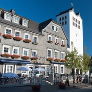
- Destination: Schmallenberg - Schützenplatz
Along the Schwammklöpper line Bad Fredeburg – Schmiedinghausen – Holthausen – Schmallenberg there are various hiking routes. This route passes through all the bus line stops. You can hike the entire route or only parts of the route and then return or continue by Schwammklöpper line.
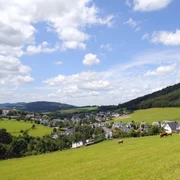
This variant leads via Bad Fredeburg to Holthausen over a short section of the Sauerland Höhenflug. Afterwards, the path leads over Gleidorf to the Wormbacher Berg and finally to Schmallenberg.
Basically, the route can also be hiked in the opposite direction.
Good to know
Best to visit
Directions
Schmiedinghausen - Bad Fredeburg - Holthausen - Gleidorf - Schmallenberg
Basically, the route can also be hiked in the opposite direction.
Tour information
Stop at an Inn
Equipment
Directions & Parking facilities
On the go with the Schwammklöpper line
The Schwammklöpper line 474 runs from Bad Fredeburg, via Schmiedinghausen and Holthausen, to the center of Schmallenberg. The new line, operated by a minibus, complements the public transport offer for passengers from the northern part of Bad Fredeburg.
Additional information
Literature
Author
Tourist-Information Schmallenberger Sauerland
Organization
Schmallenberger Sauerland Tourismus
License (master data)

Author´s Tip / Recommendation of the author
Safety guidelines
Map
Hiking map Schmallenberger Sauerland (scale 1:25,000)
You can obtain the map from Schmallenberger Sauerland Tourism.
Nearby
